翻刻
【右丁 絵図】
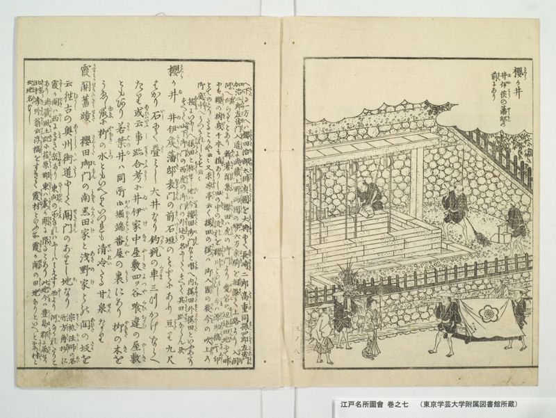
《振り仮名:櫻か井|さくら 》
井伊侯(ゐいこう)の藩邸(やしき)の
前(まへ)にあり
【左丁】
《割書:へ下(くた)る一方へは櫻田治部太輔貞國(さくらたちふのたいふさたくに)を大將(たいしやう)にて長崎二郎髙重(なかさき たかしけ) 同 孫四郎左衛門(まこしらうさゑもん)|加治二郎左衛門入道(かちしらうさゑもんにうたう)に武藏(むさし)上野(かうつけ)両國(りやうこく)の勢(せい)六万余騎( よき)を相添(あひそへ)て上路より入間(いるま) 》
《割書:河(かは)へ向(むけ)らるゝとあり新著聞集(しんちよもんしふ)に櫻田(さくたら)は《振り仮名:虎の御門|とら こもん》愛宕(あたこ)の辺迠(へんまて)田地(てんち)にて畔(くろ)|には《振り仮名:櫻の樹|さくら き 》幾千本(いく )も植(うゑ)ありし田(た)の中(なか)の流(なか)れを櫻川(さくらかは)といひし今(いま)は源助橋(えんすけはし)其印(そのしるし)》
《割書:とてのこりたるとかや云々又 求凉亭(きうりやうてい)云く桜田(さくらた)の桜(さくら)は 御入國(こにうこく)の後(のち)今(いま)の吹上(ふきあけ)の|御庭中( ていちゆう)へうつされしとそ云云》
《割書:按(あんする)にいにしへ桜田(さくらた)と称(しよう)せし地(ち)は今(いま)櫻田御門(さくらたこもん)なと唱(とな)へ内桜田(うちさくらた)外桜田(そとさくらた)といふあたり|すへて山下御門(やましたこもん)の西(にし)《振り仮名:虎の御門|とら こもん》の外迠(そとまて)の名(な)にしてすへて其(その)旧跡(きうせき)ならん欤(か)》
《振り仮名:櫻か井|さくら ゐ 》井伊矦藩邸(ゐいこうのやしき)表門(おもてもん)の前(まへ)石垣(いしかき)のもとにあり亘(わた)り九尺
はかり石(いし)にて畳(たゝ)みし大井なり釣瓶(つるへ)の車(くるま)三つかけならへ
たり或云(あるひはいふ)事跡考(しせきかう)に井伊家(ゐいけ)中屋敷(なかやしき)《振り仮名:四ツ谷|よつや》喰違(くひちかひ)の屋敷(やしき)
ともあり若葉井(わかはのゐ)は同所 御堀端番屋(おんほりはたはんや)の裏(うら)にあり栁(やなき)の木(き)を
うゑし故(ゆゑ)に《振り仮名:栁の水|やなき みつ》ともいへりいつれも清冷(せいれい)たる甘泉(かんせん)なり
《振り仮名:霞關𦾔蹟|かすみかせきのきうせき》 櫻田御門(さくらたこもん)の南(みなみ)黒田家(くろたけ)と浅野家(あさのけ)との間(あひた)の坂(さか)を
云 往古(むかし)の奥州街道(あうしうかいたう)にして關門(せきもん)のありし地(ち)なり《割書:宗祇法師(そうきほふし)の名(めい)|所方角抄(しよはうかくせう)に》
《割書:《振り仮名:霞か關|かすみ せき》は西(にし)に高(たか)き岳(をかやま)あり東向(ひかしむき)の所(ところ)なれはふしはみえす西(にし)より河(かは)なかれたりと|あり武藏風土記(むさしふとき)に荏原郡(えはらこほり)東(ひかし)は《振り仮名:霞か關|かすみ せき》に限(かき)るとあり此地(このち)今(いま)は豊島郡(としまこほり)に属(そく)せり》
《割書:北村季吟翁云(きたむらききんをういふ)《振り仮名:浮𣘺|うきはし》をすきて霞村(かすみむら)といふ所《振り仮名:霞か關|かすみ せき》の旧地(きうち)なりといへと霞村(かすみむら)と》
現代語訳
【右丁 絵図】
「桜井」
井伊侯の藩邸の
前にある
【左丁】
《割書:へ下る一方へは桜田治部太輔貞国を大将にして長崎二郎高重、同孫四郎左衛門、加治二郎左衛門入道に武蔵上野両国の勢六万余騎を相添えて上路より入間》
《割書:河へ向かわれるとあり。『新著聞集』に桜田は虎の御門、愛宕の辺りまで田地にて畔には桜の樹幾千本も植えありし田の中の流れを桜川といいし。今は源助橋その印》
《割書:として残りたるとかや云々。また『求涼亭』によれば桜田の桜は御入国の後今の吹上の御庭中へ移されしとそう云々》
《割書:按ずるに古に桜田と称せし地は今桜田御門なと唱え内桜田外桜田というあたりすべて山下御門の西虎の御門の外まての名にしてすべてその旧跡であろうか》
「桜井」井伊侯藩邸表門の前石垣のもとにあり、幅九尺
ばかり石にて畳みした大井である。釣瓶の車三つかけ並べ
たり。ある説によれば『事跡考』に井伊家中屋敷四ツ谷喰違の屋敷
ともあり。若葉井は同所御堀端番屋の裏にあり、柳の木を
植えし故に「柳の水」ともいう。いずれも清冷たる甘泉である。
「霞関旧跡」 桜田御門の南黒田家と浅野家との間の坂を
いう。往古の奥州街道にして関門のありし地である。《割書:宗祇法師の名所方角抄に》
《割書:霞ヶ関は西に高き岳あり東向きの所なればふしは見えず西より河流れたりと
あり。『武蔵風土記』に荏原郡東は霞ヶ関に限るとあり。この地今は豊島郡に属せり》
《割書:北村季吟翁曰く浮橋を過ぎて霞村という所霞ヶ関の旧地なりといえど霞村と》
英語訳
[Right page illustration]
"Sakurai" (Cherry Well)
Located in front of
Lord Ii's domain residence
[Left page]
{{Annotation: going down one direction, with Sakurada Jibu-no-taifu Sadakuni as general, accompanied by Nagasaki Jiro Takashige, the same Magoshiro Saemon, Kaji Jiro Saemon Nyudo with over 60,000 cavalry forces from both Musashi and Kozuke provinces, heading toward Iruma via the upper road}}
{{Annotation: heading toward the river. According to the "Shin Chomonju," Sakurada was farmland from Tora-no-gomon to the vicinity of Atago, with thousands of cherry trees planted on the ridges between rice fields. The stream flowing through these fields was called Sakuragawa. Now Gensuke Bridge remains as a trace}}
{{Annotation: of this, so it is said. Also according to "Kyuryotei," the cherry trees of Sakurada were transplanted to the current Fukiage imperial garden after the lord's entry into the domain}}
{{Annotation: Upon consideration, the land formerly called Sakurada encompasses the area now called Sakurada-gomon, including Uchi-Sakurada and Soto-Sakurada, all the way from west of Yamashita-gomon to outside Tora-no-gomon, and this must all be part of the old site}}
"Sakurai" (Cherry Well): Located at the base of the stone wall in front of the main gate of Lord Ii's domain residence, it is a large well about nine shaku wide, paved with stones. Three pulley wheels for water buckets are arranged side by side. According to one theory, the "Jiseki-ko" mentions this as the Ii family's middle residence at Yotsuya Kuichigai residence. Wakaba-no-i is located behind the moat-side guardhouse at the same location, and because willow trees were planted there, it is also called "Yanagi-no-mizu" (Willow Water). All of these are clear, cold sweet springs.
"Kasumigaseki Historic Site": This refers to the slope between the Kuroda and Asano family residences south of Sakurada-gomon. This was the ancient Oshu Highway where there was once a barrier gate. {{Annotation: In priest Sogi's "Meisho Hokakusho"}}
{{Annotation: Kasumigaseki has high peaks to the west and faces east, so Mount Fuji cannot be seen, and a river flows from the west. The "Musashi Fudoki" states that the eastern boundary of Ebara District is limited by Kasumigaseki. This land now belongs to Toshima District}}
{{Annotation: Elder Kitamura Kigin said that past Ukihashi there is a place called Kasumi village, which is the old site of Kasumigaseki, but Kasumi village and}}