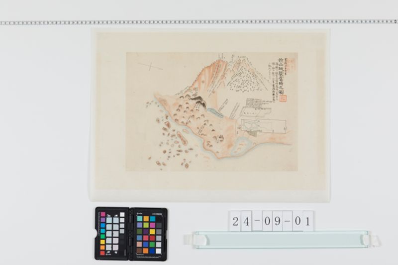
翻刻
寛政四壬子年
前山破裂当時之図
藩庁ヨリ被害之当時幕府へ差出タル
図ニ依ル記入ノ文言ハ旧藩庁報告図
ニ記入シタルモノナリ
【山の絵の上 右から1番目 逆さ文字】
此辺折々煙吹出
申候
【山の絵の上 右から2番目 逆さ文字】
当時凡五町
程
【山の絵の上 右から3番目 逆さ文字】
以前高凡八
町
【山の絵の上 右から1番目】
此谷間地震毎ニヒゞレ深ク相成候様子ニ御座候
【山の絵の上 右から2番目】
此辺岩石
谷間ニ崩落■木アバラニ残居申候
【山の絵の上 右から3番目】
此辺次第ニ崩落今少し崩候ハヽ山ハ九合ヨリ上前後ニ割通候様子ニ御座候
【山の絵の中 右から4番目】
此竪割六筋程御座候右割ヨリ 石砂崩落候様子ニモ相見
又吹出候様ニモ御座候勿論日々晴雨・差引ナク不時ニ
鳴動仕岩石谷間ニ崩落申候
【山の絵の中 右から5番目 黒い山】
此谷間折々鳴動仕候様
相見申候未 ̄タ危御座
候ニ付見分ノ者届兼申候
【山の絵の中 右から6番目】
此辺次第ニ崩落候
此穴最初ノ通リ御座候
【山の絵の中 右から7番目】
此差渡し
凡廿四町程
【小役人屋敷 足軽屋敷の上】
(上段)
此筋三月朔日地震之後見出事矣右
割深何程御座候ヤ難相分御座
候ヘトモ凡七八尺程モ可有御座右地
割小役人屋敷ヨリ城東海遠?割通
申候同所用水地割ニ落込候様ニテ
以前ゟノ水口当時出水無御座候
【小役人屋敷 足軽屋敷の左隣一番目】
此辺長間【?】幅九尺程地落入深 ̄サ凡五尺
余モ御座候右近辺畑三反■余水気
相含申候
【小役人屋敷 足軽屋敷の左隣二番目 水色の長丸の上】
此所島原村ノ内上ノ原名百姓屋敷
井戸出水強井側ヨリ吹出申候
【水色の長丸の中】
長 ̄サ南北ヘ凡八町許東西ヘ幅百
間程ノ所水湛深サ未相分不申候
【水色の長丸の下 右から一番目】
此類ノ山松木植リ
候儘押出申候
【水色の長丸の下 右からニ番目】
此類ノ山ノ内土中ヨリ押
出候様ニモ相見申候
【水色の長丸の下 右から三番目】
此辺硫黄ノ臭氏仕候
現代語訳
## 寛政四壬子年(1792年) 前山破裂当時之図
薩摩藩より被害報告として当時幕府へ差し出した図に基づく。記入の文言は旧藩廃報告図に記入されたものである。
---
### 【山の絵の上 右から1番目(逆さ文字)】
この辺りで折々(時々)煙が吹き出している模様。
### 【山の絵の上 右から2番目(逆さ文字)】
現在の高さ、九十五町ほど。
### 【山の絵の上 右から3番目(逆さ文字)】
以前の高さ、九十八町。
---
### 【山の絵の上 右から1番目】
この谷間は地震のたびに亀裂が深くなっていく様子でございます。
### 【山の絵の上 右から2番目】
この辺りは岩石が谷間に崩落し、木がまばらに残っている状態でございます。
### 【山の絵の上 右から3番目】
この辺りは次第に崩落が進み、山は九合目より上が前後に割れ通っている様子でございます。
---
### 【山の絵の中 右から4番目】
この割れ目は六筋ほどあり、また右の割れ目より石砂が崩落している様子も見受けられます。音を立てて岩石が谷間に崩落しており、危険な状況でございます。
### 【山の絵の中 右から5番目(黒い山)】
この谷間では折々(時々)音を立てており、先行きが危うい状況と見受けられます。崖の見分け(調査)もままならない状況でございます。
### 【山の絵の中 右から6番目】
この辺りは次第に崩落が進んでおります。この穴は最初の通りでございます。
### 【山の絵の中 右から7番目】
この差し渡し(直径・幅)、四町ほど。
---
### 【小役人屋敷・足軽屋敷の上】
この筋(地割れ)は三月某日の地震により現れたものと見受けられ、割れ目の深さがどれほどあるかは判明しておりませんが、七、八尺ほどはあろうかと思われます。この地割れは小役人屋敷より東の方へ割れ通り、用水路が地割れに落ち込んでいるため、以前の水口からは現在出水がございません。
### 【小役人屋敷・足軽屋敷の左隣一番目】
この辺りは長さ(間)・幅九尺ほど、地盤が陥没し深さ五尺ほどもございます。近辺の畑三反ほどに水気(湿気・水分)が含まれております。
### 【小役人屋敷・足軽屋敷の左隣二番目 水色の長丸の上】
この場所は島原村の内、上ノ原名(かみのはるみょう)の百姓屋敷の井戸から水が噴き出している状況でございます。
### 【水色の長丸の中】
南北へ長さ八町ほど、東西へ幅百間ほどの場所に水が溜まっており、深さは判明しておりません。
### 【水色の長丸の下 右から一番目】
このような(類の)山の松の木が倒れ(流され)て出てきております。
### 【水色の長丸の下 右から二番目】
このような(類の)山の内部、土中より押し出されてきている様子も見受けられます。
### 【水色の長丸の下 右から三番目】
この辺りは硫黄の臭いがいたします。
英語訳
## Kansei 4th Year, Mizunoe-Ne (1792): Diagram of the Maeyama Eruption and Collapse
This diagram was submitted to the Shogunate at the time of the disaster by the Satsuma Domain as a damage report. The written annotations are taken from the former domain's official damage report map.
---
### [Above the mountain illustration, 1st from right (inverted text)]
Smoke has been intermittently venting from this area.
### [Above the mountain illustration, 2nd from right (inverted text)]
Current height: approximately 95 *chō*.
### [Above the mountain illustration, 3rd from right (inverted text)]
Former height: 98 *chō*.
---
### [Above the mountain illustration, 1st from right]
The cracks in this valley appear to be deepening with each successive earthquake.
### [Above the mountain illustration, 2nd from right]
In this area, rocks have collapsed into the valley, and trees remain sparsely standing.
### [Above the mountain illustration, 3rd from right]
This area is gradually collapsing; the mountain above the nine-tenths elevation point appears to have split through from front to back.
---
### [Within the mountain illustration, 4th from right]
There are approximately six fissures in this area, and stone and sand can be seen collapsing from the fissures on the right side. Rocks are falling noisily into the valley, creating a dangerous situation.
### [Within the mountain illustration, 5th from right (black mountain)]
This valley intermittently makes rumbling sounds, and the future situation appears perilous. Inspection of the cliff face is extremely difficult.
### [Within the mountain illustration, 6th from right]
The collapse in this area is gradually progressing. This cavity/hole remains as it was initially observed.
### [Within the mountain illustration, 7th from right]
The breadth/width of this feature is approximately 4 *chō*.
---
### [Above the junior officials' residence and foot soldiers' quarters]
This fissure appears to have emerged during the earthquake of a certain day in the third month. Its depth is not precisely known, but it is estimated to be approximately seven to eight *shaku* deep. The fissure runs from the junior officials' residence eastward, and the irrigation channel has fallen into the fissure; consequently, there is currently no water flowing from the former water inlet.
### [First area to the left of the junior officials' and foot soldiers' quarters]
In this area, a ground subsidence of approximately 9 *shaku* in width has occurred, reaching a depth of approximately 5 *shaku*. The fields of approximately 3 *tan* in the vicinity have become waterlogged.
### [Second area to the left, above the light-blue oval]
This location is the peasant homestead known as Kaminoharu-myō, within Shimabara Village. Water is gushing vigorously from the well of this property.
### [Within the light-blue oval]
Water has accumulated in an area approximately 8 *chō* from north to south and approximately 100 *ken* from east to west. The depth is unknown.
### [Below the light-blue oval, 1st from right]
Pine trees from mountains of this type have been pushed out and are flowing forth.
### [Below the light-blue oval, 2nd from right]
It appears that material from within the earth of mountains of this type is also being pushed outward.
### [Below the light-blue oval, 3rd from right]
The smell of sulfur is present in this area.