翻刻
【右丁】
【図】
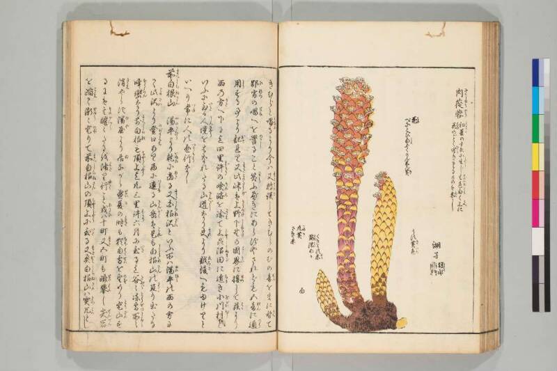
肉蓯蓉(にくしゆうやう)《割書:初夏(しよか)のすゑに生(しやう)じ其色(そのいろ)白(しろ)く上(うへ)に|花(はな)のごとく開(ひら)きたるものは赤(あか)し》
湖孑【印】
花(はな)
べにとび白(しろ)ふくりんしん黄(き)
うす黄色(きいろ)
くきうす赤(あか)
筋(すぢ)濃(こい)あか
爪(つめ)黄(き)
さき赤
白
【左丁】
きむらと唱(となふ)るより今は又(また)轉誤(てんご)してきむらのむの音(おん)をまに替(かへ)て
鄙劣(ひれつ)の唱(とな)へを詈(のゝし)ること笑(わら)ふべきにあらずやされども五 音(おん)に通(つう)
用(よう)する事より起(おこ)れり又(また)此峠(このたうげ)は上野(かうづけ)下㙒(しもつけ)の國界(こくかい)に接(せつ)して兹(こゝ)より
西の方(かた)へ下る迄四里 許(ばかり)の𡸴(けん)路(ろ)を踰(こえ)て上刕(じやうしう)沼田(ぬまだ)に近(ちか)き小川村(をがはむら)と
いふに至(いた)る人境(しんきやう)をはなれたる山道(さんだう)なり夫(それ)より越後(ゑちご)へもゆけりと
いへり常(つね)に人の通行(つうかう)なし
前白根山(まへしらねさん) 湯平(ゆのたひら)より乾(いぬゐ)に當(あた)る又(また)白根沢(しらねざは)といふ所は湯平(ゆのひら)の西の方に
て此沢(このさは)より登口(のぼりくち)あり西に連(つらな)る山岳(さんがく)は是(これ)も白根山(しらねさん)の亘(わた)り出たる
峰巒(ほうらん)なり前白根(まへしらね)も頂上(ちやうじやう)迄凢三里 許(ばかり)六月に至(いた)る迄 谷(たに)〻(〴〵)凍雪(とうせつ)所(しよ)〻(〳〵)
消(きえ)やらず湯屋(ゆや)より居(ゐ)ながら盛夏(せいか)の时(とき)も猶(なほ)白雪(はくせつ)を望(のぞ)めり登山(とうざん)す
るには其(その)皚(がい)〻(〳〵)たるを陟(わた)り行(ゆく)こと或(あるひ)は十町 又(また)五町も躋攀(せいはん)し尖岩(せんがん)
を𨂻(こえ)て漸(ぜん)〻(〳〵)登(のぼ)りて前白根山(まへしらねさん)の頂上(ちやうじやう)に至(いた)る又(また)奥白根山(おくしらねさん)は突兀(とつこつ)とし
現代語訳
【右丁】
【図】
肉蓯蓉(ニクジュヨウ)《初夏の末に生じ、その色は白く、上に花のように開いたものは赤い》
湖孑【印】
花
紅とび白縁心黄
薄黄色
茎薄赤
筋濃赤
爪黄
先赤
白
【左丁】
きむらと唱えるようになり、今はまた転訛して「きむら」の「む」の音を「ま」に替えて
下品な呼び方を罵ることは笑うべきことではないだろうか。しかし五音に通
用することから起こったのである。またこの峠は上野国と下野国の国境に接しており、ここから
西の方へ下るまで四里ほどの険しい道を越えて上州沼田に近い小川村と
いう所に至る。人里離れた山道である。それから越後へも行けると
言われている。常に人の通行はない。
前白根山 湯平から北西に当たる。また白根沢という所は湯平の西の方に
あって、この沢から登り口がある。西に連なる山岳はこれも白根山の連なり出た
峰々である。前白根も頂上まで凡そ三里ほど。六月に至るまで谷々に凍雪が所々
消えやらず、湯屋から居ながらにして盛夏の時もなお白雪を望むことができる。登山
するにはその白々としたところを渡り行くこと、或いは十町また五町も険しく登り、尖った岩
を越えて漸く登って前白根山の頂上に至る。また奥白根山は突出して高く
英語訳
【Right Page】
【Illustration】
Cistanche (Nikujūyō) 《Grows at the end of early summer, its color is white, and those that open like flowers on top are red》
Kojie【Seal】
Flower
Red spotted, white edge, yellow center
Light yellow
Stem light red
Veins dark red
Claw yellow
Tip red
White
【Left Page】
came to be called "kimura," and now through further corruption the sound "mu" in "kimura" has been changed to "ma," creating
a vulgar pronunciation - is this not laughable to criticize? However, it arose from the interchangeable use of the five sounds. Moreover, this pass borders the boundary between Kōzuke and Shimotsuke provinces, and from here
descending westward, one crosses about four ri of treacherous mountain paths to reach a place called Ogawa village
near Numata in Jōshū province. It is a mountain road far from human habitation. From there, it is said one can also go to Echigo
province. People do not regularly travel this route.
Maeshirane-san (Front Mount Shirane): Located northwest of Yuno-taira. Also, there is a place called Shirane-zawa west of Yuno-taira,
and from this valley there is a climbing entrance. The mountain range extending westward is also part of the peaks
extending from Mount Shirane. Front Shirane is also about three ri to the summit. Until June arrives, frozen snow remains
unmelted in patches throughout the valleys, and from the hot spring inns, one can view white snow even during midsummer. When climbing
the mountain, one must traverse these brilliant white areas, sometimes climbing steeply for ten or five chō, crossing sharp rocks
and gradually ascending to reach the summit of Front Shirane Mountain. Also, Mount Oku-Shirane rises abruptly and