翻刻
【見開き 絵図】
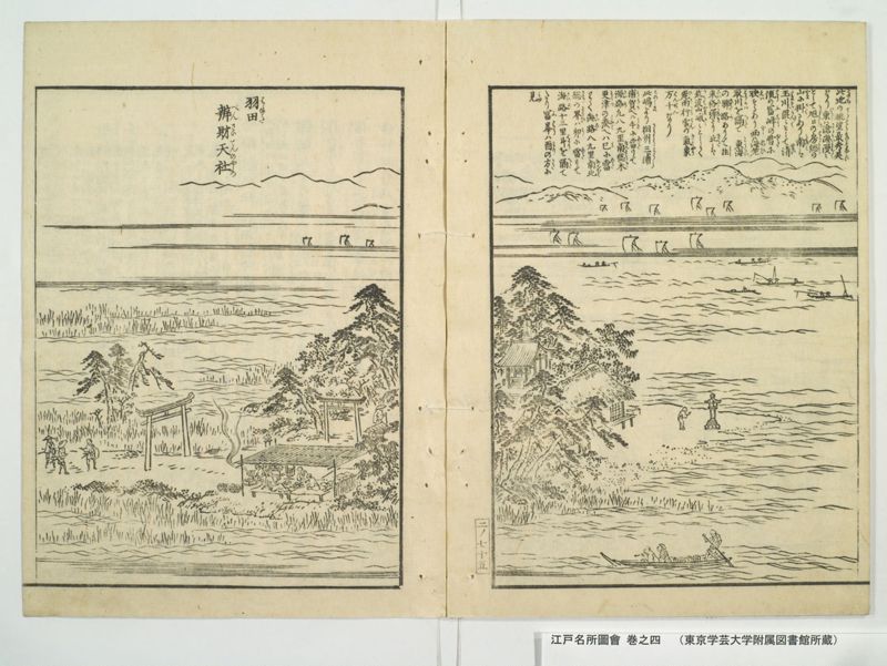
【右丁】
此地(このち)の眺望(てうはう)最(もつとも)秀美(しうひ)
なり東(ひかし)は滄海(さうかい)漫々(まん〳〵)
として旭日(きよくしつ)の房総(はうさう)の
山(やま)に掛(かく)るあり南(みなみ)は
玉川(たまかは)混々(こん〳〵)として清(せい)
流(りう)の冨峰(ふはう)の雪(ゆき)に
映(えい)するあり西(にし)は海老(ゑひ)
取川(とりかは)を隔(へた)て 東海(とうかい)
の驛路(ゑきろ)ありて往(わう)
来(らい)絡驛(らくゑき)たり北(きた)は
筑波山(つくはやま)峨々(かゝ)として
飛雨(ひう)行雲(かううん)の氣象(きしやう)
万千(はんせん)なり
此嶋(このしま)より相州(さうしう)三浦(みうら)
浦賀(うらか)へは午(うま)に當(あた)りて
海路(かいろ)凡八九里 南総(なんさう)木(き)
更津(さらつ)の湊(みなと)へは巳(み)に當(あた)
りて海路(かいろ)八九里 南北(なんほく)
総(さう)の界(さかひ)は卯(う)に當(あた)りて
海路(かいろ)十三里 斗(はかり)を隔(へた)て
たり冨峯(ふはう)は酉(とり)の方(かた)に
見(みゆ)
本社
【左丁】
羽田(はねた)
辨財天社(べんさいてんのやしろ)
現代語訳
【見開き 絵図】
【右丁】
この地の眺望は最も美しい。東は青い海が広々と広がり、旭日が房総の山にかかっている様子がある。南は多摩川がゆったりと流れ、清流が富士山の雪に映える様子がある。西は海老取川を隔てて東海道の宿場道があり、往来が絶えない。北は筑波山が高くそびえ、雨雲や流れる雲の気象変化が様々である。
この島(羽田)から相模国三浦の浦賀へは南南東の方角で海路およそ八、九里。安房国木更津の湊へは南東南の方角で海路八、九里。安房・上総の国境は東の方角で海路十三里ほど隔てている。富士山は西の方角に見える。
本社
【左丁】
羽田
弁財天社
英語訳
【Double-page spread illustration】
【Right page】
The scenic view from this location is most beautiful. To the east, the blue sea spreads endlessly, with the morning sun hanging over the mountains of Bōsō Peninsula. To the south, the Tama River flows gently, and the clear stream reflects against the snow of Mount Fuji. To the west, across the Ebitori River, lies the Tōkaidō highway with its constant flow of travelers. To the north, Mount Tsukuba rises majestically with ever-changing weather patterns of rain clouds and flowing clouds.
From this island (Haneda) to Uraga in Miura, Sagami Province, it is about eight to nine ri by sea route in the south-southeast direction. To Kisarazu port in Awa Province, it is eight to nine ri by sea route in the east-southeast direction. The border between Awa and Kazusa provinces is about thirteen ri away by sea route to the east. Mount Fuji can be seen to the west.
Main Shrine
【Left page】
Haneda
Benzaiten Shrine