翻刻
【右側欄外 上部】極本細しらべ 【同 下部】近在難渋人大坂町内中より施行致候事誠におびたゞしく筆記かたく
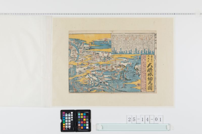
【上段】
四月中旬より閏四月中旬迄雨天多く閏月十五日
入梅に相成候て七八日続て御天気の所廿日過より
五月八日迄大体雨天計り九日十日天気十一日より十五日
明方迄昼夜降通し候ゆへ堺大和橋より二三丁計り
川上にてうりの村南の方の堤十三日申上刻凡巾
四十間余切れ込其水勢三尺計りの波打うづ巻立て
水先戌の方へ押行其おそろしさ見る物目のまはるごと
またゝく間に押流れ死人夥敷同所中程より北なにはや
松は申に不及住吉鳥居前より壱丁余北まて
往来にて四五尺の水ゆへ船にて見舞いたし候誠に
愁至極目もあてられぬ次第に候○又淀川筋は淀の
小橋落候ゆへ其材木天満橋へかゝり十二日夜七ツ時
天満橋中ほど卅間余流れ落候天神橋浪花橋は
いまた無難なれ共十三日より往来とまり候又川上は平太と申
所にてきれ込み候ゆへ中嶋郷は江口三番新家新庄国じま
宗禅寺馬場其外村々一円家根迄水漬りに相成候○
中津川に而は横ぜきと申所切れこみ三番村十三村ゑび江ひゑ
嶋浦江其余村々北野辺迄一円大洪水○東はとくあん堤
辺に而切れこみ候ゆへすみのどう辺より東の山ぎは申に
不及大坂より東の在一円のこらず白海のことくに有之候
○西は下福島野田村伝法等に而堤小川所々切れこみ何れも
大水に御座候○大坂市中に而は北の新地三丁目より
西は往来にて深き所は壱尺四五寸水下 ̄タ ばらに而は【注】
床の上にて二尺三尺の水なり堂島の下も中の島
の下も其ほかすべて川々の水下も場所にては川と
往来と一流に相成候所有之候又往来にて所々より
壱尺或は二尺往来に穴あき候も有之死人けが
人等こゝかしこに有之候誠に八九十年来の間未聞の
大洪水にて中々筆紙に尽しがたくいまだ高水に而
諸方の往来とまり候ゆへ此外遠方之儀はおい〳〵
相知れ候はんあゝ誠に古今の大洪水なれかし
【下段】
《題:《割書:慶応四|戊辰年》大洪水細見図》
此外 近江 丹波 播州 阿州 讃岐 伊予 土佐 紀州 勢州
所国路 山城 大和 美濃 尾州 関東すしにいたるまで諸国
一円の大洪水のよしなれ共不便にてくわしくはしるしかたく略之
【注 東京大学情報学環本館蔵小野秀雄コレクション『大洪水細見図』慶応4年(1868)。の飜刻文は「下タばら之内は」とあり。一方、大阪市立図書館デジタルアーカイブの『大洪水の次第』(http://image.oml.city.osaka.lg.jp/archive/viewer?cls=ancient&pkey=n0044001&lCls=media&lPkey=195975)は被害状況の記事部分が殆ど同文で筆跡も似ていることから恐らく同一人物の書いたものと思われる。それには該当部分がこの資料の様に行尾に詰めて書いたようではなく、行の中程にはっきりと「下タ(小さく) ばらニてハ」とありますのでそれに決定する。】
現代語訳
【右側欄外 上部】非常に詳細な調査 【同 下部】近郊の困窮者に大阪町内中より施しを行ったことは誠におびただしく、筆記することが困難
【上段】
4月中旬より閏4月中旬まで雨天が多く、閏月15日に入梅となって7、8日続けて晴天だったところ、20日過ぎより5月8日まで大体雨天ばかり。9日、10日は晴天、11日より15日明け方まで昼夜降り通したため、堺の大和橋より2、3町ほど川上にて瓜生村南の方の堤防が13日申の上刻(午後3時頃)におよそ幅40間余り決壊し、その水勢は3尺ほどの波打ってうず巻き立て、水先は西の方へ押し行き、その恐ろしさは見る者の目が回るほど。またたく間に押し流され死人が夥しい。同所中程より北、難波や住吉は言うに及ばず、住吉鳥居前より1町余り北まで往来にて4、5尺の水のため船にて見舞いたし候。誠に憂愁至極、目も当てられぬ次第である。○また淀川筋は淀の小橋が落ちたため、その材木が天満橋へかかり、12日夜七つ時(午後4時頃)に天満橋中ほど30間余りが流れ落ちた。天神橋、浪花橋はまだ無事だが、13日より往来が止まった。また川上は平太という所にて決壊したため、中島郷は江口、三番、新家、新庄、国島、宗禅寺、馬場その外村々一円家根まで水浸しになった。○中津川にては横堰という所が決壊し、三番村、十三村、海老江、比江島浦江その余村々北野辺まで一円大洪水。○東は徳庵堤辺にて決壊したため、住道辺より東の山際は言うに及ばず、大阪より東の在郷一円残らず白海のようになった。○西は下福島、野田村、伝法等にて堤防が小川所々で決壊し、何れも大水であった。○大阪市中にては北の新地3丁目より西は往来にて深い所は1尺4、5寸の水。下平野では床の上にて2尺3尺の水なり。堂島の下も中の島の下もその他すべて川々の水下も場所によっては川と往来が一流になった所がある。また往来にて所々より1尺或いは2尺往来に穴が開いた所もあり、死人怪我人等があちらこちらにある。誠に80、90年来の間未聞の大洪水にて、とても筆紙に尽くし難く、いまだ高水にて諸方の往来が止まっているため、この外遠方の儀はおいおい分かるであろう。ああ誠に古今の大洪水であることよ。
【下段】
《題:《慶応4年戊辰年》大洪水細見図》
この外 近江 丹波 播州 阿州 讃岐 伊予 土佐 紀州 勢州
所の国々 山城 大和 美濃 尾州 関東に至るまで諸国一円の大洪水のようだが、不便にて詳しくは記し難く略す。
英語訳
【Right margin top】Extremely detailed investigation 【Same, bottom】Relief efforts provided by Osaka townspeople for people in distress in nearby areas were truly enormous and difficult to record in writing
【Upper section】
From mid-April to mid-intercalary April, there were many rainy days. The rainy season began on the 15th day of the intercalary month, and after 7-8 days of continued fair weather, from past the 20th until May 8th it was mostly rainy weather. The 9th and 10th were fair, but from the 11th until dawn of the 15th it rained continuously day and night. Therefore, about 2-3 chō upstream from Yamato Bridge in Sakai, the embankment on the south side of Uryū village broke at approximately the hour of the Monkey (around 3 PM) on the 13th, with a width of over 40 ken. The force of the water created waves about 3 shaku high, swirling and surging, pushing westward. The terror was such that observers felt dizzy. In an instant people were swept away and there were countless deaths. From the middle of that location northward, not to mention Namba and Sumiyoshi, from in front of Sumiyoshi Torii to over 1 chō north, the roads had 4-5 shaku of water, so people went to check by boat. It was truly extremely sorrowful, unbearable to witness. ○ Also on the Yodo River, because Yodo's small bridge fell, its lumber caught on Temma Bridge, and at the seventh hour of the night (around 4 PM) on the 12th, over 30 ken of the middle of Temma Bridge was washed away. Tenjin Bridge and Naniwa Bridge were still intact, but from the 13th, traffic was stopped. Also upstream at a place called Heita there was a breach, so in Nakajima-gō, Eguchi, Sanban, Shinja, Shinjō, Kunijima, Sōzenji, Baba and other villages were completely flooded up to the rooftops. ○ At Nakatsu River, a place called Yokozeki broke, and Sanban village, Jūsan village, Ebie, Hiejima, Urae and other villages up to the Kitano area were all severely flooded. ○ To the east, there was a breach near Tokuānn embankment, so from around Sumidō eastward to the foot of the mountains, not to mention all the rural areas east of Osaka, everything became like a white sea. ○ To the west, at Shimofukushima, Noda village, Dempō and other places, embankments broke at various small river locations, all experiencing major flooding. ○ In Osaka city proper, from the 3rd block of Kita-no-shinchi westward, the roads had water 1 shaku 4-5 sun deep in the deepest places. In Shimohirano, there was 2-3 shaku of water above floor level. Below Dōjima and below Nakanoshima, and elsewhere, depending on the location below the various rivers, there were places where rivers and roads became one flow. Also on the roads, there were places where holes 1 or 2 shaku deep opened up, and there were dead and injured people here and there. Truly an unprecedented great flood in 80-90 years, impossible to fully describe in writing. The water is still high and traffic in all directions remains stopped, so news from other distant places will gradually become known. Ah, truly a great flood for the ages.
【Lower section】
《Title: Great Flood Detailed Map of Keiō 4, Boshin Year》
Besides this: Ōmi, Tanba, Banshū, Ashū, Sanuki, Iyo, Tosa, Kishū, Seshū and other provinces, Yamashiro, Yamato, Mino, Bishū, extending to Kantō - it appears there were great floods throughout all provinces, but it is inconvenient and difficult to record details, so this is abbreviated.