翻刻
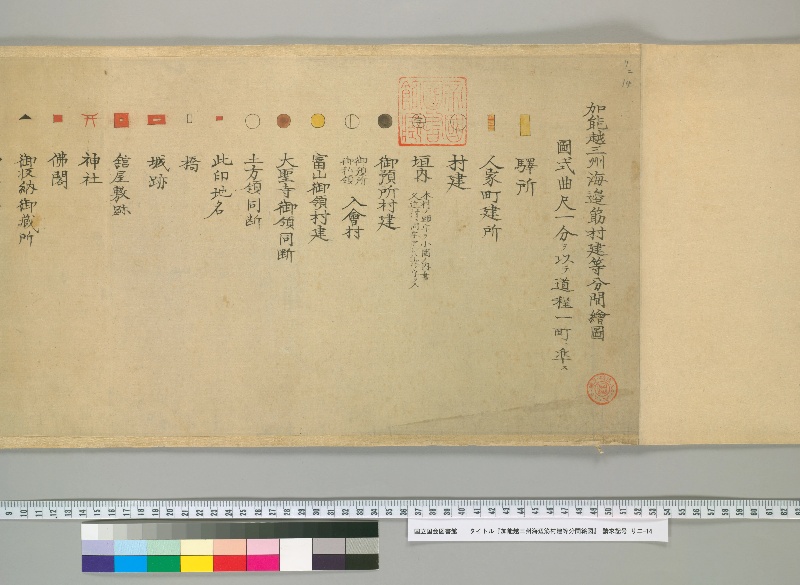
加能越三州海邊筋村建等分間繪圖 ㊞
圖式曲尺一分ヲ以テ道程一町ニ準ス
【長方形:縦黄】驛所
【長方形:縦黄に赤で横縞】人家町建所
【円】村建
【円:内に字】垣内 《割書:本村ノ頭字ヲ小圏ノ内書|又近村ニ同字アレハ次ノ字ヲ入》
【円:黒】御預所村建
【円:縦線】《割書:御預所|御私領》入会村
【円:黄色】富山御領村建
【円:茶】大聖寺御領同断
【円】土方領同断
【長方形:横赤】此印地名
【四角:縦】橋
【長方形:横赤・中抜き】城跡
【正方形:赤・中抜き】舘屋敷跡
【鳥居】神社
【正方形:赤】仏閣
【三角:黒】御収納御藏所
現代語訳
加賀・能登・越中三州海辺筋村建等分間絵図 ㊞
図式 曲尺一分をもって道程一町に準ずる
【縦長方形:黄色】駅所
【縦長方形:黄色に赤で横縞】人家町建所
【円】村建
【円:内に字】垣内 《割書:本村の頭字を小圏の内に書く|また近村に同字があれば次の字を入れる》
【円:黒】御預所村建
【円:縦線】《割書:御預所|御私領》入会村
【円:黄色】富山御領村建
【円:茶色】大聖寺御領同断
【円】土方領同断
【横長方形:赤】この印地名
【四角:縦】橋
【横長方形:赤・中抜き】城跡
【正方形:赤・中抜き】館屋敷跡
【鳥居】神社
【正方形:赤】仏閣
【三角:黒】御収納御蔵所
英語訳
Detailed Survey Map of Coastal Villages in the Three Provinces of Kaga, Noto, and Etchu ㊞
Chart Legend: One bu of the carpenter's square corresponds to one chō of distance
【Vertical rectangle: yellow】Post stations
【Vertical rectangle: yellow with red horizontal stripes】Residential town areas
【Circle】Village settlements
【Circle with characters inside】Kakiuchi (hamlet) 《Marginal note: The first character of the main village name is written inside a small circle | If there is a village with the same character nearby, the next character is added》
【Circle: black】Villages under direct shogunate administration
【Circle: vertical lines】《Marginal note: Shogunate administration|Private domain》Jointly administered villages
【Circle: yellow】Villages under Toyama domain
【Circle: brown】Villages under Daishōji domain (same)
【Circle】Villages under Hijikata domain (same)
【Horizontal rectangle: red】Place name marker
【Square: vertical】Bridge
【Horizontal rectangle: red, hollow】Castle ruins
【Square: red, hollow】Mansion site ruins
【Torii gate】Shrine
【Square: red】Buddhist temple
【Triangle: black】Shogunate granary