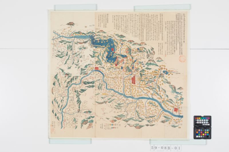
翻刻
弘化丁未春三月廿四日信州大地震山頽川塞湛水之図
〇三代実録《割書:五|十》曰 光孝天皇仁和三年丁未七月晦日《割書:辛|丑》申 ̄ノ時地大 ̄ニ震動 ̄シ経_二歴 ̄シテ数剋_一 ̄ヲ震 ̄コト猶不_レ止 天皇出_二 ̄テ仁寿殿_一 ̄ニ御_二 ̄ス
紫宸殿 ̄ノ南庭_一 ̄ニ命_二大蔵 ̄ノ省_一 ̄ニ立_二 ̄テ七丈幄二_一 ̄ツ為_二 ̄ス御在所_一 ̄ト諸司 ̄ノ舎屋及東西 ̄ノ京盧舎往々 ̄ニ顚覆圧殺 ̄スル者衆 ̄シ或 ̄ハ有_二失_レ ̄ヒ神 ̄ヲ頓死 ̄スル者_一亥ノ
時亦震三度五畿七道 ̄ノ諸国同日 ̄ニ大震 ̄ヒ官舎多 ̄ク損 ̄シ海潮漲_レ ̄リ陸 ̄ニ溺死 ̄スル者不_レ ̄ト可_二勝 ̄テ計_一 ̄フ云_二
〇扶桑略記《割書:廿|二》曰《割書:上略|如録文》今日信乃国大山頽崩 ̄レ巨河溢流 ̄シ六郡城盧払_レ ̄テ地 ̄ヲ漂 ̄ヒ流 ̄ル牛馬男女流死成_レ ̄スト丘 ̄ヲ云_二
私考_レ之距_二 ̄コト於今弘化丁未_一凡九百六十一年矣然シテ仁和丁未ノ変我国六郡ミナ以テ蕩尽スト史籍スデニソノ
地名ヲ不_レ戴暦数僅ニ千年口碑伝ルコトナシ偏ニ雖_レ不_レ可_レ徴(チヤウ) ̄ス按ルニ六郡ヲ貫通スル巨河恐クハ犀千隈ノ
雨流ニ過ズ《割書:岐蘇天龍大井|姫川等不及之》這回(コノタビ)ノ大変最甚キモノ水内(ミヌチ)更級(サラシナ)ニシテ上ハ筑摩(ツカマ)安曇(アヅミ)ヲ浸淩シ下ハ埴科(ハジナ)高井ヲ漂
蕩ス概(オホムネ)水災ノ所_レ及殆 ̄ト六郡人畜圧溺セラルヽ者亦仁和ノ厄ノ如シ今俗以為古今未曽有ナリト僕コヽニ有_二
微志_一即ソノ境ニ到リ攀渉スルコト数次シ後遂ニ是図を製シ竊ニ家筺ニ蔵シテ聊 ̄カ後戒ニ便ゼントス事倉卒
ニ出 ̄ヅ精粗マタ見聞ニ任スト云 信中 平昌言識【落款】
【上下二段の内上段】
〇古伝 ̄ニ曰 推古帝十五年大仁《割書:六位|官名》鳥臣(トリノオミヲ)往_二 ̄シニ東国 ̄ニ【一点脱ヵ】廻_二 ̄リ箕野(ミノ)_一 ̄ニ至_二 ̄リ科野(シナノ)_一 ̄ニ治_二水内(ミヌチノ)海_一 ̄ヲ至_二 上毛(カミツケ)_一 ̄ニ
治_二 ̄ム利根(トネノ)海_一 ̄ヲ乃 ̄チ割_二 ̄リ戸河 ̄ノ瀧磐(イハ)_一 ̄ヲ入_二雁越(カリコシ)_一 ̄ニ開_二 ̄ク栗柄 ̄ノ路及 上邑(アゲロノ)路_一 ̄ヲ云_二
按るに水内郡水内邑は本郡初発の地にして上古に
水内の海と聞へしも此辺をいへるにや今なを北の郡に大沼あまたあり
これそのなごりなるべしこの地北は戸隠の峻嶮(けはしき)により東南に犀川を
帯ひ西に境川あり東に澣花川(すゝはな)川ありいはゆる島をなせり実に水内
橋の奇巧(たくみ)なかりせは便りなかるべしおもふにみぬちの谷こゝに出し
にやあらん《割書:壒襄鈔 善光寺 ̄ノ来由ノ条 ̄ニ云信乃ハ高キ地ナルニ殊ニコノ郡ノ高ケレハ水落ノ郡也トイヘレド我国|十郡ノ地最厚高ニシテ天下ノ上流タリナンゾ是郡ヲ以テ高シトセンオボツカナシ》
水内の曲橋《割書:又久米路ノ橋トモ云歌枕名寄ニ信乃トス又来目ノ岩橋ナド詠ルハ大和ノ葛城ニ在ト|拾遺集 埋木は中むしはむといふめればくめぢの橋は心してゆけ よみ人しらす》
〇日本紀曰 推古天皇二十年自_二百済国_一有_二化来者_一其面身皆班白巧 ̄ニ掛_二長橋_一 ̄ヲ時
人號_二 ̄シテ其人_一 ̄ニ曰_二路子工_一 ̄ト又号_二 ̄クト芝耆麻呂_一 ̄ト云_二
〇古伝 ̄ニ曰 推古帝二十年百済国 帰化(オノヅカラクル) ̄ノ人《割書:中略|如紀文》巧(タクミ) ̄ニ掛_二長橋_一令_レ造_下遣_二 ̄シテ諸国_一 ̄ニ三河国
八 脛(ハギノ)長橋水内 ̄ノ曲橋 木襲(キソノ)梯(カケハシ)遠江国浜名 ̄ノ橋会津 闇(クロ)川 ̄ノ橋 兜岩(カヒノ)猿橋等其外一百八十橋_上 ̄ヲ
云_二これらの説出処詳ならざるのよしは先輩已に考按あれは今更に
贅(ぜい)するに及はずたゞその一二を抄略してこゝに掲(かゝぐ)るのみ
此地両山はなはだ狭り犀河の水たぎりて落かの北 涯(きし)の半腹(なかば)を
うがちて酉(にし)より卯(ひかし)へゆく事五丈四尺曲て南へ大橋をわたす長 ̄サ十丈
五尺広 ̄サ壱丈四尺 欄(らん)基の高 ̄サ三尺橋と水との間尋常にて凡
十五丈《割書:或云三|十三尋》碧潭(あをきふち)のみなぎるさまみるに肝(きも)すさまし
心してゆけとよみしいにしへにそもなをかはらざりける
しかるに今災(こんさい)《割書:弘化|丁未》三月下旬 湛(たゝへ)水既に橋上数丈に及ひ
橋梁(はしげた)さかしまに浮みながれて穂刈(ほかり)《割書:村|名》の水面に漂(たゝよ)ふ
四月十三日崩流してゆく処をしらす《割書:下流奥郡に|漂着するもの》
《割書:徑り三尺余長 ̄サ十丈余|これその橋材なるにや》此頃歩を徙(うつ)してかの遺跡に臨(のそ)み
里人についてこれを尋るに両岸《割書:立|岩》こと〴〵く
崩れ落残水たゝへてなを数丈 再架(ふゝたひかくる)の
術(てだて)ほとんど絶たりと嗚呼陵谷の変ある
千載の名蹟こゝにほろびん欤又をしむ
へき事ならすや
穂高(ホタカ)神社《割書:延喜式神名帳名神大|安曇郡穂高邑に坐す》
〇古事記曰 綿(ワタ)津見 ̄ノ神は阿 曇連(ツミノムラシ)等之(ノ)祖 ̄ト云_二
〇姓氏録曰安曇 ̄ノ宿祢 ̄ハ海 ̄ノ神綿 積(ツミ)豊玉
彦 ̄ノ子穂高見 ̄ノ命 ̄ノ後 ̄ト云_二
此地草昧の時水を治め玉ひし神に
ませはその勲功(みいさほ)かしこみて仰べし
【下段】
いはゆる川中島四郡ははじなさらしな
みぬちたかゐなり盛衰記東鑑等 ̄ニ云
しなの奥郡にして今も里言おくの郡といふ
現代語訳
弘化丁未春三月二十四日信州大地震山崩川塞湛水之図
○三代実録(五十)に言う。光孝天皇仁和三年丁未七月晦日(辛丑)申の刻に地が大きく震動し、数刻にわたって続き、震動は止まなかった。天皇は仁寿殿から出て紫宸殿の南庭に御し、大蔵省に命じて七丈の幄舎を立てて御在所とされた。諸司の舎屋及び東西の京の盧舎が往々にして顚覆し、圧死する者が多く、あるいは失神して頓死する者もあった。亥の時にまた三度震え、五畿七道の諸国が同日に大きく震え、官舎が多く損傷し、海潮が陸に漲って溺死する者は数え切れないほどであったという。
○扶桑略記(二十二)に言う。(上略、録文の如し)今日信濃国の大山が崩れ落ち、大河が溢れ流れ、六郡の城盧が地を払い漂い流れ、牛馬男女が流死して丘をなしたという。
私考:これより今の弘化丁未まで凡そ九百六十一年である。しかして仁和丁未の変では我が国の六郡がみな蕩尽したと史籍にある。すでにその地名を載せず、歳月わずかに千年、口碑も伝わることがない。ひとえに徴証し難いとはいえ、六郡を貫通する大河を按ずるに、おそらく犀川・千曲川の二流に過ぎない(岐阜の木曽川、天竜川、大井川、姫川等は及ばない)。この度の大変で最も甚だしいのは水内・更級であって、上は筑摩・安曇を浸し陵ぎ、下は埴科・高井を漂蕩させた。概して水災の及ぶところ、殆ど六郡の人畜が圧溺されることは仁和の厄の如くである。今俗はこれを古今未曽有なりという。僕はここに微志あり、すなわちその境に到り攀じ渉ること数次、後遂にこの図を製し、ひそかに家筺に蔵してささやかながら後戒に便せんとする。事は倉卒に出で、精粗はまた見聞に任すという。
信中 平昌言識
【上段】
○古伝に言う。推古帝十五年、大仁(六位の官名)鳥臣を東国に往かせ、美濃を廻り科野に至り、水内の海を治め、上毛に至り利根の海を治めた。すなわち戸隠山の瀧磐を割り、雁越に入り、栗柄の路及び上邑の路を開いたという。
按ずるに水内郡水内邑は本郡発祥の地にして、上古に水内の海と聞こえしも、この辺りをいうのであろうか。今なお北の郡に大沼が数多あり、これがその名残りであろう。この地は北は戸隠の峻険により、東南に犀川を帯び、西に境川あり、東に澣花川あり、いわゆる島をなしている。実に水内橋の奇巧がなければ便りがないであろう。思うに水内の谷がここに出たのであろうか。
水内の曲橋(また久米路の橋とも云う。歌枕名寄に信濃とする。また来目の岩橋などと詠むのは大和の葛城にあるという。拾遺集「埋木は中虫食むというめれば久米路の橋は心してゆけ よみ人しらず」)
○日本紀に言う。推古天皇二十年、百済国より化来者あり。その面身皆斑白で、巧みに長橋を掛けた。時の人はその人を路子工と号し、また芝耆麻呂と号したという。
○古伝に言う。推古帝二十年、百済国帰化の人(中略、紀文の如し)巧みに長橋を掛け、諸国に遣わして造らしめ、三河国八脛の長橋、水内の曲橋、木曽の梯、遠江国浜名の橋、会津闇川の橋、甲斐の猿橋等その外一百八十橋を造ったという。
これらの説の出処は詳らかでないが、先輩がすでに考按されているので今更贅するに及ばず、ただその一二を抄略してここに掲げるのみである。
この地は両山がはなはだ狭く、犀河の水がたぎりて落ち、あの北岸の半腹を穿って西より東へ行くこと五丈四尺、曲がって南へ大橋を渡す。長さ十丈五尺、広さ一丈四尺、欄干の高さ三尺、橋と水との間は尋常にて凡そ十五丈(或いは三十三尋と云う)。碧潭のみなぎる様を見るに肝がすさまじく、「心してゆけ」と詠んだ昔もなお変わらざりける。
しかるに今災(弘化丁未)三月下旬、湛水すでに橋上数丈に及び、橋梁さかしまに浮み流れて穂刈(村名)の水面に漂う。四月十三日崩流して行く処を知らず(下流奥郡に漂着するもの、径り三尺余長さ十丈余、これがその橋材なるか)。この頃歩を移してかの遺跡に臨み、里人について これを尋ぬるに、両岸(立岩)ことごとく崩れ落ち、残水湛えてなお数丈、再架の術ほとんど絶たりという。ああ陵谷の変あり、千載の名跡ここに滅びんか、また惜しむべき事ではないか。
穂高神社(延喜式神名帳名神大、安曇郡穂高邑に坐す)
○古事記に言う。綿津見神は阿曇連等の祖という。
○姓氏録に言う。安曇宿祢は海神綿積豊玉彦の子穂高見命の後という。
この地草昧の時、水を治め給いし神にませば、その勲功を畏みて仰ぐべし。
【下段】
いわゆる川中島四郡は埴科・更級・水内・高井なり。盛衰記・東鑑等に言う信濃奥郡にして、今も里言で奥の郡という。
英語訳
Illustration of the Great Earthquake in Shinano Province, Mountain Collapses, River Blockages and Flooding on March 24th, Spring of Kōka Hinoto-Hitsuji Year
○The Sandai Jitsuroku (Volume 50) states: On the last day of the seventh month of the third year of Ninna, Hinoto-Hitsuji year, during the reign of Emperor Kōkō, at the hour of the monkey (saru), the earth shook violently for several hours without stopping. The Emperor left Jinjuden Hall and went to the southern courtyard of Shishinden Hall, ordering the Ministry of the Treasury to erect a seven-jō tent as his temporary residence. Many governmental buildings and residences in the eastern and western capitals collapsed, crushing many people to death, and some died instantly from shock. At the hour of the boar (i), there were three more tremors. All provinces of the five home provinces and seven circuits experienced great earthquakes on the same day. Many official buildings were damaged, and sea tides surged onto land, drowning countless people.
○The Fusō Ryakki (Volume 22) states: (omitting the beginning, as in the record) On this day, great mountains in Shinano Province collapsed, great rivers overflowed, castle towns in six districts were swept away by the floods, and cattle, horses, men and women died in the floods, forming hills of corpses.
Personal reflection: From that time to the present Kōka Hinoto-Hitsuji year is approximately 961 years. The historical records state that during the Ninna Hinoto-Hitsuji disaster, all six districts of our province were completely devastated. The place names are no longer recorded, and after barely a thousand years, no oral traditions remain. Although verification is difficult, examining the great rivers that run through the six districts, they are probably nothing more than the Sai River and Chikuma River (the Kiso, Tenryu, Oi, and Hime rivers of Gifu do not compare). In this recent great disaster, the worst affected areas were Minochi and Sarashina districts, with flooding reaching up to Chikuma and Azumi districts above, and sweeping down to Hanishina and Takai districts below. Generally, where the flood damage reached, nearly all people and livestock in the six districts were crushed or drowned, just like the Ninna disaster. People today say this is unprecedented in history. I have a humble intention here: I visited that region several times, climbing and wading through it, and finally created this illustration, secretly storing it in my family chest to serve as a lesson for future generations. The matter occurred suddenly, and the details depend on what I saw and heard.
Shinchū Hei Shōgen (signature and seal)
[Upper section]
○Ancient tradition states: In the 15th year of Empress Suiko's reign, Taijin (6th court rank official title) Tori no Omi was sent to the eastern provinces, traveled through Mino, reached Shinano, governed the Minochi Sea, went to Kōzuke, and governed the Tone Sea. He then split the rocky rapids of Mount Togakushi, entered Karikoshi, and opened the Kurigara Road and Agero Road.
Examining this: Minochi village in Minochi district was the original site of this district's founding, and what was called "Minochi Sea" in ancient times probably referred to this area. Even now there are many large marshes in the northern districts, which are probably remnants of that. This land is bounded by the steep险 of Mount Togakushi to the north, bordered by the Sai River to the southeast, with Sakai River to the west and Susuhana River to the east, forming what is called an island. Without the ingenious construction of Minochi Bridge, there would be no means of passage. I think the Minochi Valley emerged here.
Minochi Curved Bridge (also called Kumejino Bridge, listed under Shinano in the Utamakura Myōyose. The Iwabashi of Kurume mentioned in poems is said to be in Katsuragi, Yamato. Shūi-shū: "The buried wood is said to be eaten by insects within, so cross Kumejino Bridge with care" - author unknown)
○The Nihon Shoki states: In the 20th year of Empress Suiko's reign, there came naturalized people from Baekje Kingdom. Their faces and bodies were all mottled white, and they were skilled at building long bridges. The people of the time called this person "Rojikō" and also "Shigimaro."
○Ancient tradition states: In the 20th year of Empress Suiko's reign, naturalized people from Baekje Kingdom (details omitted, as in the chronicles) skillfully built long bridges and were sent to various provinces to construct them: the long bridge of Yahagi in Mikawa Province, the curved bridge of Minochi, the suspension bridge of Kiso, the bridge of Hamana in Tōtōmi Province, the bridge of Kuro River in Aizu, the monkey bridge of Kai, and 180 other bridges in total.
Since the sources of these accounts are not detailed and have already been examined by previous scholars, there is no need to elaborate further. I merely excerpt one or two points and present them here.
At this location, the two mountains are extremely narrow, and the Sai River's waters rush and fall, carving through the middle of the northern bank from west to east for 5 jō 4 shaku, then curving south where a great bridge spans it. Length: 10 jō 5 shaku, width: 1 jō 4 shaku, railing height: 3 shaku. The normal distance between bridge and water is about 15 jō (some say 33 hiro). The sight of the blue-green deep pool surging is terrifying to the liver, and the ancient poem "cross with care" remains as true as ever.
However, during the recent disaster (Kōka Hinoto-Hitsuji), in late March, the flood water already reached several jō above the bridge, and the bridge beams floated upside down and drifted to the water surface at Hokari (village name). On April 13th, they collapsed and flowed away to unknown places (some drifted to downstream districts; those over 3 shaku in diameter and over 10 jō in length may have been bridge materials). Recently, I moved on foot to visit those ruins and inquired with local people: both banks (standing rocks) had completely collapsed, remaining water still pooled several jō deep, and the means for reconstruction were almost completely lost. Alas, with such changes to hills and valleys, will this thousand-year famous site perish here? Is this not also a matter for regret?
Hotaka Shrine (listed in the Engishiki Jinmyōchō as a great deity, located in Hotaka village, Azumi district)
○The Kojiki states: The deity Watatsumi is the ancestor of the Azumi no Muraji clan.
○The Seishi-roku states: Azumi no Sukune are descendants of Hotakamino-mikoto, child of the sea deity Watatumi Toyotamahiko.
Since this was a deity who governed waters in the early days of this land, we should revere and look up to those meritorious achievements with awe.
[Lower section]
The so-called four districts of Kawanakajima are Hanishina, Sarashina, Minochi, and Takai. The Genpei Jōsuiki, Azuma Kagami and other sources call this the inner districts of Shinano, and even today local people call them "the inner districts."