翻刻
冨岡手暠校正
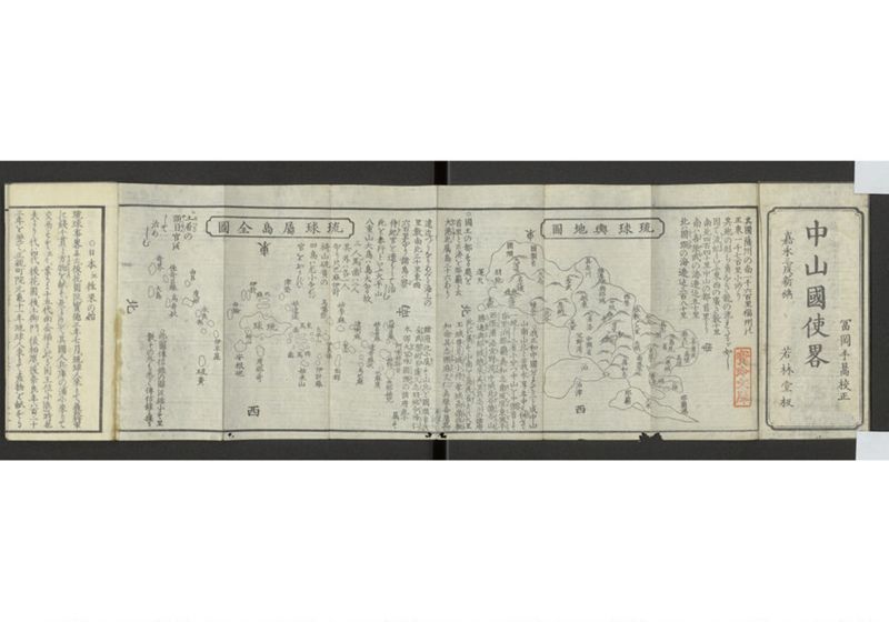
中山国使略
嘉永三戌新鐫 若林堂板
【蔵書印「寶玲文庫」】
其国薩州の南一千六百里福州の
正東一千七百里にあり
其地の形ち角なき龍の流れたるが如し
因て流虬(りうきう)といふ東西の広さ数十里
南北四百四十里中山の都首里より
南ハ喜屋武(きやむ)の海辺迠五十里
北ハ国頭(くにきや)の海辺迠三百八十里
琉球輿地図
南
東 西
北
【図中地名】
島尻省
佐敷 知念 具志頭 麻文仁 真壁 喜屋武
大里 玉城 豊見城 小禄 兼城 高嶺
中頭省
東風平 南風原 真和志 那覇 久米 那覇港
首里
勝連 與那城 中城 西原
具志川 越来 浦添 美里 宜野湾 泊 泊津
北谷 読谷山
国頭省
久志 金武 恩納
国頭 大宜味 名護 今帰仁
羽地 本部 運天
○我正和中国分れて三と成中山
山南山北と云我永享年中又/併(あは)せて
一統し三省に分つ中山を中/頭(きや)省とす
首里(しゆり)泊(とまり)那覇(なは)真和志/南風原(はへばる)東風平(こちたいら)
西原(にしばる)浦添/宜野湾(きのわん)中城/北谷(きや)読谷山(よんたんさん)
勝連(かつれん)與那城(よなぐすく)越来(こへく)美里(みさと)具志川の諸府
此に属(ぞく)す山南を島尻省(しましりせい)とす大里
玉城/豊見城(とみくすく)小禄(をろく)兼城/高嶺(たかみね)佐敷(さしき)
知念/具志頭(くしきや)麻文仁(まふい)真壁喜屋武の
諸府此に属(ぞく)す山北を国頭省とす
金武(き*たけ)恩納(おぐな)名護(なこ)久志(くし)羽地(はち)今帰仁(いまきにん)
本部/大宜味(おほきみ)国頭(くにきや)の諸府此に属す
○国王の都する処を
首里と云湊を那覇と云
大港(おほみなと)也属島三十六あり
遠近つらなりめぐる海上の
里数南北三千里東西
六百里なり諸島は察(ざ)
侍紀(しき)官を遣はして治しむ
此を奉行といふ大平山
八重山大島は島大なる故
三人/馬歯(ばし)は二人
其外は各一人
なり只巴麻伊計
椅山硫黄の
四島は尤小なれば
官をおかず◇
◇土着(ゐつき)の
頭目(やくにん)官を
して治めしむ
琉球属島全図
南
東 西
北
【図中地名】
阿喇姑斯古
巴梯呂麻 姑弥 巴麻度 由那姑咒
姑呂世麻 達奇麻奴 烏巴麻
達喇麻 八重山 面郡
姑李麻 伊良保
烏噶弥 太平山 伊計麻
津堅 姑達佳 東馬歯 西馬歯 姑米山
琉球
巴麻 伊計 由論
度那奇 椅山 安根㞾 伊平屋 硫黄
由呂 度姑 永良部
佳奇呂麻 烏奇奴
奇界 大島
○此二図伝信録の図を縮小す里
数その外も悉く伝信録に拠る
現代語訳
富岡手暠校正
中山国使略
嘉永三年戌新刊 若林堂板
【蔵書印「寶玲文庫」】
その国は薩摩州の南一千六百里、福州の正東一千七百里にある。
その地の形は角のない龍が流れるようで、
そのため流虬(りゅうきゅう)という。東西の広さは数十里、
南北四百四十里。中山の都首里から
南は喜屋武の海辺まで五十里、
北は国頭の海辺まで三百八十里である。
琉球輿地図
南
東 西
北
【図中地名】
島尻省
佐敷 知念 具志頭 麻文仁 真壁 喜屋武
大里 玉城 豊見城 小禄 兼城 高嶺
中頭省
東風平 南風原 真和志 那覇 久米 那覇港
首里
勝連 与那城 中城 西原
具志川 越来 浦添 美里 宜野湾 泊 泊津
北谷 読谷山
国頭省
久志 金武 恩納
国頭 大宜味 名護 今帰仁
羽地 本部 運天
○わが正和年間に国が分かれて三つになり、中山、山南、山北といった。わが永享年間に再び併せて統一し、三省に分けた。中山を中頭省とする。
首里、泊、那覇、真和志、南風原、東風平、
西原、浦添、宜野湾、中城、北谷、読谷山、
勝連、与那城、越来、美里、具志川の諸府が
これに属する。山南を島尻省とする。大里、
玉城、豊見城、小禄、兼城、高嶺、佐敷、
知念、具志頭、麻文仁、真壁、喜屋武の
諸府がこれに属する。山北を国頭省とする。
金武、恩納、名護、久志、羽地、今帰仁、
本部、大宜味、国頭の諸府がこれに属する。
○国王が都とする所を首里といい、港を那覇という。
大港である。属島三十六がある。
遠近に連なり巡る海上の
里数は南北三千里、東西
六百里である。諸島には察侍紀官を派遣して治めさせる。
これを奉行という。大平山、
八重山、大島は島が大きいので
三人、馬歯は二人、
その外は各一人
である。ただ巴麻、伊計、
椅山、硫黄の
四島は最も小さいので
官を置かず、
土着の
頭目(役人)に
治めさせる。
琉球属島全図
南
東 西
北
【図中地名】
阿喇姑斯古
巴梯呂麻 姑弥 巴麻度 由那姑呪
姑呂世麻 達奇麻奴 烏巴麻
達喇麻 八重山 面郡
姑李麻 伊良保
烏噶弥 太平山 伊計麻
津堅 姑達佳 東馬歯 西馬歯 姑米山
琉球
巴麻 伊計 由論
度那奇 椅山 安根夷 伊平屋 硫黄
由呂 度姑 永良部
佳奇呂麻 烏奇奴
奇界 大島
○この二図は『伝信録』の図を縮小したものである。里数その他もすべて『伝信録』に拠る。
英語訳
Corrected by Tomioka Tekō
A Brief Account of Envoys from the Kingdom of Chūzan
Newly published in Kaei 3 (1850), Year of the Dog - Wakabayashi-dō edition
【Library seal "Hōrei Bunko"】
That country is located 1,600 ri south of Satsuma Province and 1,700 ri due east of Fuzhou.
The shape of the land is like a flowing dragon without corners,
hence it is called Ryūkyū (flowing dragon). The width from east to west is several dozen ri,
and from north to south 440 ri. From Shuri, the capital of Chūzan,
south to the seashore of Kyan is 50 ri,
north to the seashore of Kunigami is 380 ri.
Map of Ryukyu Territory
South
East West
North
【Place names in the map】
Shimajiri Province
Sashiki Chinen Gushikami Mabuni Makabe Kyan
Ōzato Tamaki Tomigusuku Oroku Kanegusuku Takamine
Nakagami Province
Kochinda Haebaru Mawashi Naha Kume Naha Port
Shuri
Katsuren Yonashiro Nakagusuku Nishihara
Gushikawa Goeku Urasoe Misato Ginowan Tomari Tomari Port
Chatan Yomitan
Kunigami Province
Kyushi Kin Onna
Kunigami Ōgimi Nago Nakijin
Haneji Motobu Unten
○During our Shōwa period [should be "Shōhei"], the country was divided into three parts called Chūzan, Nanzan, and Hokuzan. During our Eikyō period, they were again unified and divided into three provinces. Chūzan became Nakagami Province.
The various districts of Shuri, Tomari, Naha, Mawashi, Haebaru, Kochinda,
Nishihara, Urasoe, Ginowan, Nakagusuku, Chatan, Yomitan,
Katsuren, Yonashiro, Goeku, Misato, and Gushikawa
belong to this province. Nanzan became Shimajiri Province. The various districts of Ōzato,
Tamaki, Tomigusuku, Oroku, Kanegusuku, Takamine, Sashiki,
Chinen, Gushikami, Mabuni, Makabe, and Kyan
belong to this province. Hokuzan became Kunigami Province.
The various districts of Kin, Onna, Nago, Kyushi, Haneji, Nakijin,
Motobu, Ōgimi, and Kunigami belong to this province.
○The place where the king has his capital is called Shuri, and the port is called Naha.
It is a great harbor. There are thirty-six tributary islands.
Extending far and near across the surrounding seas,
the distance is 3,000 ri from north to south and
600 ri from east to west. Officials called sashiki are dispatched to govern the various islands.
These are called bugyō. Taiheisan,
Yaeyama, and Ōshima are large islands, so
three people [govern them]; Bashi has two people;
the others each have one person.
However, the four islands of Bama, Ikei,
Isusan, and Iō
are very small, so
no officials are stationed there.
Local
headmen (officials)
are made to govern them.
Complete Map of Ryukyu's Tributary Islands
South
East West
North
【Place names in the map】
Aragusuku
Baderu-ma Komi Bamado Yunagoju
Korosema Dakimanu Ubama
Darama Yaeyama Mengūn
Korima Irabo
Ukāmi Taiheisan Ikeima
Tsuken Kodaka Higashi-bashi Nishi-bashi Komeyama
Ryukyu
Bama Ikei Yoron
Donaki Isusan Angami Iheya Iō
Yuro Doko Erabu
Kakēroma Ukinu
Kikai Ōshima
○These two maps are reduced versions of maps from the "Denshinroku." The distances in ri and other details are all based on the "Denshinroku."