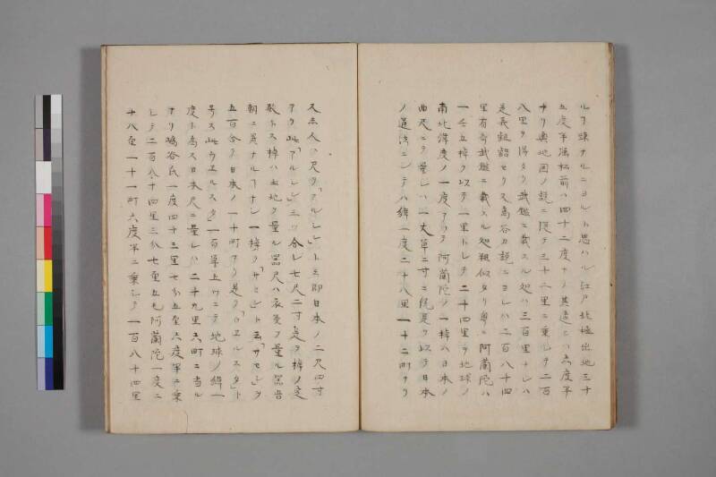
翻刻
【右丁】
ルヿ疎ナルニヨルト思ハル江戸北極出地三十
五度半強松前ハ四十二度ナリ其違ヒハ六度半
ナリ輿地図ノ説ニ従テ三十二里ニ乗シテ二百
八里ヲ得タリ武鑑ニ載スル処ハ三百里ナレハ
是義齟齬セリ又島谷カ説ニヨレハ二百八十四
里有奇武鑑ニ載スル処粗似タリ粤ニ阿蘭陀ハ
一壬#1五棹ヲ以テ一里トレテ二十四里ヲ地球ノ
南北緯度ノ一度アツテ阿蘭陀ノ一棹ハ日本ノ
曲尺ニテ量レハ一丈単二寸ニ統是ヲ以テ日本
ノ道法ニシテハ緯一度二十八里一十二町ナリ
【左丁】
又赤人ハ尺ヲ「アルシン」ト云即日本ノ二尺四寸
アリ此「アルシン」三ッ合レ七尺二寸是ヲ棹ノ定
数トス棹ハ土地ヲ量ル器尺ハ衣類ヲ量ル器吾
朝ニ異ナルヿナシ一棹ヲ「サセン」ト云「サセン」ヲ
五百合テ日本ノ一十町アリ是ヲ「ウヱルスタ」ト
号ス此ウヱルスタ」一百単五ツニテ地球ノ緯一
度ト為ス日本尺ニ量レハ二十九里六町ニ当ル
ナリ嶋谷氏一度四十三里七分五厘六度半ニ乗
シテ二百八十四里三分七厘五毛阿蘭陀一度ニ
十八厘一十一町六度半ニ乗シテ一百八十四里
現代語訳
## (右丁・本文)
……(これは天文・数象の道が)疎(おろそか)であることによると思われる。江戸の北極出地(北緯)は三十五度半強、松前は四十二度である。その差は六度半である。輿地図の説に従って(一度あたり)三十二里を(六度半に)乗じると、二百八里を得る。(しかし)武鑑に載せるところは三百里であるから、これ(輿地図の説)は実情と齟齬をきたしている。また、島谷の説によれば二百八十四里余りとなり、武鑑に載せるところとおおむね似ている。そもそも、オランダは一壬(ロープ)五棹(サオ)をもって一里とし、二十四里を地球の南北緯度の一度に当てている。オランダの一棹は、日本の曲尺で量れば一丈単(ちょうど)二寸に統じる。これをもって日本の道法(距離の単位)に換算すると、緯度一度は二十八里一十二町となる。
## (左丁・本文)
また、ロシア人は尺を「アルシン」という。すなわち日本の二尺四寸に当たる。この「アルシン」三つを合わせると七尺二寸となり、これを棹(サオ)の定数とする。棹は土地を量る器であり、尺は衣類を量る器である。わが国(日本)と異なるところはない。一棹を「サセン」という。「サセン」を五百合わせると日本の一十町となる。これを「ウェルスタ」と号す。この「ウェルスタ」百単(ちょうど)五つをもって地球の緯度一度とする。日本の尺で量れば二十九里六町に当たる。
〔まとめとして各説の比較〕
島谷氏の説では一度を四十三里七分五厘とし、六度半を乗じると二百八十四里三分七厘五毛となる。オランダの一度は二十八里一十一町(二十八里一十二町)とし、六度半を乗じると百八十四里……
英語訳
## (Right folio — main text)
…I believe this (the lack of familiarity with astronomy and mathematical reckoning) is due to neglect of these fields. The north polar altitude (*hokkyoku shutsuchi*, i.e., latitude) of Edo is slightly more than 35.5 degrees, while that of Matsumae is 42 degrees. The difference between them is 6.5 degrees. Following the theory set forth in the world atlas (*Yochizu*) and multiplying 32 *ri* (per degree) by 6.5, one obtains 208 *ri*. However, the figure recorded in the *Bukan* (the official directory of feudal lords) is 300 *ri*, and so this (world atlas) figure is inconsistent with that record. According to Shimaya's theory, the distance works out to 284-odd *ri*, which is roughly in accord with the figure given in the *Bukan*. Now, the Dutch take five poles (*sao*) per *rin* (rope unit) as one *ri*, assigning 24 such *ri* to one degree of the earth's north-south latitude. One Dutch pole, when measured in Japanese *kanejaku* (carpenter's square measure), amounts to exactly 1 *jō* and 2 *sun*. Converted into Japanese units of distance, one degree of latitude thus equals 28 *ri* and 12 *chō*.
## (Left folio — main text)
Furthermore, the Russians call their unit of length a "Arshin" (*arushin*). This is equivalent to 2 *shaku* and 4 *sun* in Japanese measure. Three "Arshin" combined equal 7 *shaku* and 2 *sun*, and this is established as the length of one pole (*sao*). The pole is an instrument for measuring land, while the *shaku* is an instrument for measuring cloth — in this respect there is no difference from our own country. One pole is called a "Sazen" (*sasen*). Five hundred "Sazen" equal ten *chō* in Japanese measure. This unit is called a "Versta" (*uerusuta*). One hundred and five "Versta" are taken as one degree of the earth's latitude. Converted into Japanese measure, this equals 29 *ri* and 6 *chō*.
〔Summary comparison of the various theories〕
Under Shimaya's theory, one degree equals 43 *ri*, 7 *bu*, and 5 *rin*; multiplied by 6.5 degrees, this yields 284 *ri*, 3 *bu*, 7 *rin*, and 5 *mō*. Under the Dutch calculation, one degree equals 28 *ri* and 11–12 *chō*; multiplied by 6.5, this yields 184 *ri*…
*(The passage continues.)*