翻刻
【右丁】
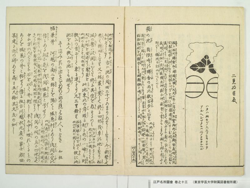
二見将監殿
【旗指物残欠の図、旗内の文字】
ハタハ此モンノ上三ツヒキリヤウ
アルヘシマクニハ二ノクロカルヘシ
《割書:按(あんする)に相州(さうしう)鎌倉(かまくら)《振り仮名:松か岡|まつ をか》過去帳(くわこちやう)に天文(てんぶん)七年十月七日 生実御所左兵衛督義明(おひみごしよさひやうゑのかみよしあきら)八正院(はつしやうゐん)|空善道哲(くうせんたうてつ)と注(ちゆう)したり空哲(くうてつ)の二字(にじ)を分(わけ)て空善道哲(くうせんたうてつ)とせし欤(か)然(しか)らばこの古文書(こもんしよ)は》
《割書:義明(よしあきら)より二見将監(ふたみしやうげん)へ給ひしものなるべし花押(くわあふ)をもて考(かんが)ふるに義(よし)の字(じ)の如(ごと)しされど|義明(よしあきら)花押(くわあふ)は花押藪(くわあふすう)続花押藪(ぞくくわあふすう)古押藪(こあふすう)等(とう)の書(しよ)にもこれを漏(もら)せる故(ゆゑ)に考(かんが)ふる》
《割書:所(ところ)なし猶(なほ)他日(たじつ)訂正(ていしやう)すべきのみ》
《振り仮名:箱の池|はこ いけ》 箱根崎(はこねがさき)の駅舎(えきしや)の西北(にしきた)数百歩(すひやくほ)にあり《割書:此地(このち)は八王子(はちわうじ)より野州(やしう)日光山(につくわうさん)|への通路(つうろ)にして六七月の間(あひだ)は》
《割書:奥羽(あうう)等(とう)の国々(くに〳〵)より相州(さうしう)大山(おほやま)へ登(のぼ)らんとする輩(ともがら)過半(くわはん)此(こゝ)に出(いづ)る故(ゆゑ)に其頃(そのころ)は往来(わうらい)頗(すこぶ)る多(おほ)し|箱根権現(はこねごんげん)を以(もつて)鎮守(ちんしゆ)とする故(ゆゑ)《振り仮名:箱根が崎|はこね さき》と称(しよう)したるか或(あるひ)は箱根崎(はこねかさき)と号(がう)する故(ゆゑ)に此(この)》
【左丁】
《割書:御神(おんかみ)を勧請(くわんじやう)せしや|今(いま)知(しる)べからず》古(いにしへ)は池(いけ)の周回(めぐり)三十丁あまりありしとなり今(いま)は新墾(にひばり)して
悉(こと〴〵)く耕田(こうでん)となり又は林叢(りんさう)と変(へん)して纔(はつか)に凹形(あふぎやう)茂草(もさう)の地(ち)となり松(まつ)
風(かぜ)の響(ひゞき)は波瀾(はらん)にかはり纔(はつか)に其俤(そのおもかげ)を存(そん)するのみ《割書:今(いま)方(はう)四五十歩( ほ)ばかりの|池(いけ)の中(なか)に小嶼(こしま)ありて弁(べん)》
《割書:天(てん)の小祠(やしろ)を営建(えいこん)せり蓴菜(しゆんさい)を|此地(このち)の産(さん)とす尤(もつとも)佳味(かみ)なり》此地(このち)東北(とうほく)の岸頭(がんとう)に起(おこ)る所(ところ)の一峰(いつほう)は則(すなはち)
狭山(さやま)の首(はじめ)にして東(ひがし)に連(つらな)る事 凡(およそ)三里余( あま)り《割書:将軍塚(しやうぐんつか)の辺(あたり)を以(もつ)て|此山(このやま)の東(ひかし)の終(をは)りとす》故(ゆゑ)に此(この)
池(いけ)を土人(とじん)《振り仮名:狭山の池|さやま いけ》とも称(しよう)せり
冬深み箱の池辺を朝行は氷の鏡見ぬ人そなき 知経
堀兼井(ほりかねのゐ) 河越(かはこえ)の南(みなみ)二里余( あま)りを隔(へだ)てゝ堀兼村(ほりかねむら)にあり《振り仮名:浅間の宮|せんけん みや》の
傍(かたはら)にある故(ゆゑ)に是(これ)を浅間堀兼(せんけんほりかね)と号(がう)せり《割書:此(この)社前(しやぜん)は古(いにしへ)の鎌倉街道(かまくらかいたう)に|して上州(しやうしゆう)信州(しんしう)への往還(わうくわん)の》
《割書:行路(かうろ)なり今(いま)の宮(みや)は慶安中(けいあんちゆう)松平豆州侯(まつたいらづしうこう)建立(こんりふ)なし|給へり別当(べつたう)を慈雲庵(じうんあん)と号(がうす)河越(かはこえ)高林院(かうりんゐん)の持(もち)なり》《振り仮名:浅間の祠|せんけん やしろ》の左(ひだり)に凹地(くぼかなるち)有(あり)て
中に方(はう)六尺( しやく)ばかりに石(いし)を以(もつ)て井桁(ゐけた)とし半(なかば)土中(どちゆう)に埋(うづも)れたるもの
あるを《振り仮名:堀兼の井|ほりかね ゐ 》と称(しよう)せり傍(かたはら)に往古(そのかみ)川越秋元侯(かはこえあきもとこう)の家士(かし)岩田(いはた)
某(それがし)建(たつ)る所(ところ)の碑(ひ)あり高(たか)さ五尺余(ごしやくよ)其文(そのぶん)左(さ)の如(ごと)し
現代語訳
【右丁】
二見将監殿
〔旗指物残欠の図(旗の切れ端の図)、旗内の文字〕
旗はこの紋の上に三つ引き(横線三本)があるべし。幕には二つの黒(横線)があるべし。
〔考えるに、相州鎌倉の松が岡(円覚寺)の過去帳に、「天文七年十月七日、生実御所左兵衛督義明、八正院空善道哲」と注記されている。「空哲」の二字を分けて「空善道哲」としたものであろうか。そうであれば、この古文書は義明から二見将監へ与えられたものであるはずだ。花押をもって考えてみると、「義」の字のように見える。しかし義明の花押は、『花押藪』・『続花押藪』・『古押藪』等の書にも掲載されていないため、確認する手立てがない。なお、後日訂正すべきことである。〕
**箱の池** 箱根崎の宿場(駅舎)の西北、数百歩のところにある。〔この地は八王子から野州(下野国)日光山への通路であり、六・七月の間は、奥羽などの諸国から相州大山へ登ろうとする人々の過半数がここを通るため、その頃は往来が非常に多い。箱根権現を鎮守とするゆえに「箱根が崎」と称したのか、あるいは「箱根崎」と号するゆえにこの
【左丁】
御神を勧請したのか、今はもはや知ることができない。〕昔は池の周囲が三十丁余りあったというが、今は新たに開墾されてことごとく耕作地となり、また林や茂みに変じて、わずかに低くなった地形に草が茂るばかりとなり、松風の響きが波のように聞こえて、かろうじてその面影を留めているに過ぎない。〔現在は、周囲四・五十歩ほどの池の中に小島があり、弁天の小さな祠が建てられている。じゅんさい(蓴菜)をこの地の産物とし、とりわけ風味がよい。〕この地の東北の岸辺から起こる一峰は、すなわち狭山の始まりであり、東へ連なること凡そ三里余り〔将軍塚のあたりをもってこの山の東の端とする〕。ゆえにこの池を土地の人は「**狭山の池**」とも称している。
冬深み 箱の池辺を 朝行は 氷の鏡 見ぬ人ぞなき 知経
**堀兼井** 河越の南、二里余り隔てた堀兼村にある。浅間の宮の傍らにあるゆえに、これを「浅間堀兼」と号している。〔この社の前は、昔の鎌倉街道であり、上州・信州への往還の行路である。現在の宮は慶安年中に松平豆州侯が建立なさったものである。別当を慈雲庵と号し、河越高林院の管理に属する。〕浅間の祠の左手に窪地があり、その中に方(一辺)六尺ほどの石をもって井桁とし、半ば土中に埋もれているものを、「**堀兼の井**」と称している。傍らに、往古、川越秋元侯の家士・岩田某が建てた碑があり、高さ五尺余り。その文は左のとおりである。
英語訳
**[Right Folio]**
To Futami Shōken
*[Illustration of a remnant of a battle standard (hatasashimono), with text inscribed within the flag:]*
> The flag should have three horizontal stripes (*mitsu-biki*) above this crest. The curtain (*maku*) should have two black stripes.
*(Upon reflection: In the mortuary register (*kakochō*) of Matsugaoka [Engaku-ji] in Kamakura, Sagami Province, the following entry appears: "Seventh year of Tenbun [1538], tenth month, seventh day — Ōimi Gosho Sahyōe-no-kami Yoshiaki, Hasshō-in Kūzen Dōtetsu." Perhaps the two characters "Kūtetsu" were divided and rendered as "Kūzen Dōtetsu." If so, this ancient document would be one that Yoshiaki presented to Futami Shōken. Examining the monogram (*kaō* [cursive seal]), it appears to resemble the character for "Yoshi" (義). However, since Yoshiaki's monogram is omitted from reference works such as the* Kaōyabu, *the* Zoku Kaōyabu, *and the* Ko-Ōyabu, *there is no means of verification. This matter should be corrected at a later date.)*
**Hako-no-Ike (Box Pond)** This pond is located several hundred paces to the northwest of the post station (*ekisha*) at Hakonegasaki. *(This area lies along the route from Hachiōji to Nikkō-san in Shimotsuke Province (Yashū), and during the sixth and seventh months, more than half of the pilgrims traveling from the provinces of Ōu and elsewhere to climb Mount Ōyama in Sagami Province pass through here, making it a very busy thoroughfare at that season. Whether the area came to be called "Hakonegasaki" because Hakone Gongen was enshrined here as the tutelary deity, or whether this deity was invited here because the place was already called "Hakonegasaki,"*
**[Left Folio]**
*can no longer be determined.)* In ancient times the circumference of the pond was said to be over thirty *chō* (approximately 3.3 kilometers), but now it has been entirely reclaimed and converted into cultivated fields or transformed into woodland, leaving only a slight depression overgrown with grass, where the sound of wind through the pines serves as a substitute for the sound of waves—thus the pond barely preserves its former semblance. *(At present, within a small pond of about forty to fifty paces in circumference, there is a small islet upon which a little shrine to Benzaiten has been constructed. Water shield (*junsai*, *Brasenia schreberi*) is a local product of this area and is said to be of particularly fine flavor.)* The single peak that rises from the northeastern shore of this site marks the beginning of the Sayama hills, which extend eastward for approximately three *ri* (about 12 kilometers) *(the vicinity of Shōgunzuka being taken as the eastern terminus of these hills)*. For this reason, local people also call this pond "**Sayama-no-Ike** (Sayama Pond)."
> *Fuyu fukami / Hako no ike-be wo / asa yukeba / kōri no kagami / minu hito zo naki*
> (In the depths of winter, walking along the shores of Hako Pond at dawn, there is no one who fails to behold the mirror of ice.) — *Tomochika*
**Horikane-no-I (The Horikane Well)** This is located in Horikane Village, over two *ri* (approximately 8 kilometers) to the south of Kawagoe. Since it lies beside the Sengen Shrine (*Asama-no-miya*), it is designated "Asama Horikane." *(The area in front of this shrine was the ancient Kamakura Highway (*Kamakura kaidō*), the road leading to Kōzuke and Shinano Provinces. The current shrine building was erected during the Keian era [1648–1652] by Lord Matsudaira Zushū. The administrative temple (*bettō*) is called Jiunan and belongs to the management of Kōrin-in in Kawagoe.)* To the left of the Sengen Shrine there is a depression in the ground, within which a stone well-frame (*igeta*) measuring approximately six *shaku* (about 1.8 meters) on each side, half-buried in the earth, is called the "**Horikane-no-I**" (the Horikane Well). Beside it stands a stone monument erected in former times by one Iwata, a retainer of Lord Akimoto of Kawagoe, measuring over five *shaku* (about 1.5 meters) in height. Its inscription reads as follows.