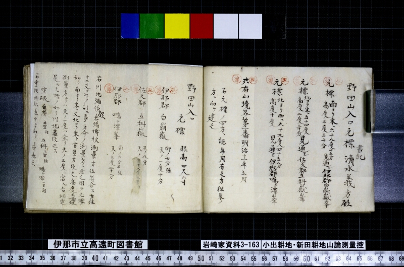
翻刻
【右丁】
書記
野田山入口元標 清水義方殿
【印 原】
元標《割書:南ヨリ東、六十八度十五分|高度三度三十分》見通シ伊那郡白崩嶽峯
【印 三澤】
【印 原】
元標《割書:北ヨリ東、五十四度|高度二度ニ十分》見通シ佐久郡立科嶽峯
【印 三澤】
【印 原】
元標《割書:北ヨリ西、六十九度四十五分|高度十度》見通シ伊那瑪ヶ沢山峯
【印 三澤】
【印 原】
共有山境界第一番明治十一年五月
【印 三澤】
右元標ノ四方、認年月有之方往来ノ
方、向ヶ建之
【左丁】
野田山入口
元標 眼高 四尺六寸
【印 原】
伊那郡 白崩嶽 《割書:卯ノ七分強|天ノ一度十分》
【印 三澤】
【印 原】
佐久郡 立科山嶽 《割書:丑ノ八分|天ノ五十分、六里ヨ》
【印 三澤】
【印 原】
伊那郡 ■ヶ澤峰 《割書:西ノ六分半強|天ノ三度二十分》
【印 三澤】
右川地禰作殿岩崎博秋測量方位符合ス方位
十二丈ヲ以テ計ル事方今ノ測量方ニ無之固テ元標ノ
如ク南ヨリ東、又北ヨリ東ト官員方改之高度モ博秋
測量方ニテハ天ノ一度ハ全ク天ノ三度ニ当ル上田相達
是モ元標ノ如ク川地悉改正ス
空眼白崩五里弱 立科十一里強 ■ヶ沢嶋一里弱
右空眼博秋意中ニテ測リ上申無之
現代語訳
【右丁】
書記
野田山入口元標 清水義方殿
【印 原】
元標《方位:南より東へ六十八度十五分/仰角三度三十分》見通し 伊那郡白崩嶽峰
【印 三澤】
【印 原】
元標《方位:北より東へ五十四度/仰角二度二十分》見通し 佐久郡立科嶽峰
【印 三澤】
【印 原】
元標《方位:北より西へ六十九度四十五分/仰角十度》見通し 伊那玛ヶ沢山峰
【印 三澤】
【印 原】
共有山境界第一番 明治十一年五月
【印 三澤】
右元標の四方、年月を記した面を往来の
方向に向けて建てること。
【左丁】
野田山入口
元標 目の高さ 四尺六寸(約百三十九センチ)
【印 原】
伊那郡 白崩嶽 《方位:卯の七分強(東北東寄り)/仰角一度十分》
【印 三澤】
【印 原】
佐久郡 立科山嶽 《方位:丑の八分(北北東寄り)/仰角五十分、六里より》
【印 三澤】
【印 原】
伊那郡 ■ヶ沢峰 《方位:西の六分半強(西南西寄り)/仰角三度二十分》
【印 三澤】
右は川地禰作殿と岩崎博秋の測量による方位が符合する。方位を十二丈をもって計ることは、現在の測量方法にはないため、元標に記したように南より東、また北より東というように官員の方で改められた。仰角についても博秋の測量方法では、天(仰角)の一度は完全に天(仰角)の三度に相当するとの上田への通達があり、これも元標のとおり川地がすべて改正した。
空眼(目測)による距離:白崩 五里弱、立科 十一里強、■ヶ沢嶋(嶺) 一里弱
右の空眼による距離は博秋の見当(推測)にて測ったものであり、正式に上申したものではない。
英語訳
[Right Folio]
Secretary
Nodayama Entrance Benchmark To: Mr. Shimizu Yoshikata
[Seal: Hara]
Benchmark 《Bearing: S68°15'E / Elevation angle: 3°30'》 — Line of sight to: Ina District, Shirakuzure-dake Peak
[Seal: Misawa]
[Seal: Hara]
Benchmark 《Bearing: N54°E / Elevation angle: 2°20'》 — Line of sight to: Saku District, Tateshina-dake Peak
[Seal: Misawa]
[Seal: Hara]
Benchmark 《Bearing: N69°45'W / Elevation angle: 10°》 — Line of sight to: Ina, ■ga-sawa Mountain Peak
[Seal: Misawa]
[Seal: Hara]
Communal Mountain Boundary, No. 1 — Meiji Year 11 (1878), May
[Seal: Misawa]
The benchmark post is to be erected with its four faces
oriented so that the face bearing the date faces toward the
main thoroughfare.
[Left Folio]
Nodayama Entrance
Benchmark Eye height: 4 shaku 6 sun (approx. 139 cm)
[Seal: Hara]
Ina District Shirakuzure-dake 《Bearing: approx. E by N (7/10 past Uto, i.e., ENE) / Elevation angle: 1°10'》
[Seal: Misawa]
[Seal: Hara]
Saku District Tateshina-dake 《Bearing: approx. NNE (8/10 past Ushi, i.e., NNE) / Elevation angle: 0°50', from approx. 6 ri》
[Seal: Misawa]
[Seal: Hara]
Ina District ■ga-sawa Peak 《Bearing: approx. WSW (6.5/10 past Nishi, i.e., WSW) / Elevation angle: 3°20'》
[Seal: Misawa]
The bearings from the above survey by Mr. Kawachi Nesaku and Iwasaki Hakushū are in agreement. The method of measuring bearings using the unit of 12 jō is not found in current surveying practice, and therefore government officials revised the notation to the style as written on the benchmark — namely "degrees east of south" and "degrees east of north." Regarding the elevation angles as well, there was a notice sent to Ueda indicating that in Hakushū's surveying method, 1 degree of elevation (ten) is equivalent to 3 degrees in the standard method; accordingly, Kawachi corrected all of these in accordance with the benchmark records.
Line-of-sight (estimated) distances: Shirakuzure — just under 5 ri; Tateshina — just over 11 ri; ■ga-sawa Ridge — just under 1 ri.
The above line-of-sight distances were estimated by Hakushū and have not been formally submitted as an official report.