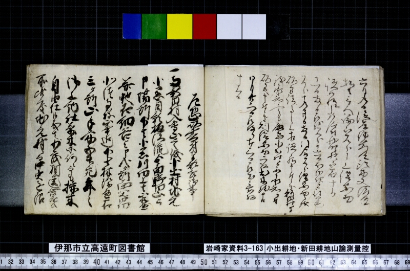
翻刻
【右丁】
六月九日後藤仲右衛門殿鈴木又清左衛門殿
杣之三人論山見分申上絵図面
請候様ニ被仰付西町村岩十郎
十一日両日罷越見分十六日何日云也
見分十九日廿日両日引合見分借図向之儀
双方諸事之上相認候様申付候処秋田村々
致承知候へとも麻島小出村に而不承知に付
双方へ申候所則絵図面に被出来致申候
四月廿二日罷帰り廿三日罷出委細
申上候
【左丁】
乍恐以書付奉願上候御事
一当新田村入会山ニ候儀小出村地元
小黒目影板沢流ゟ南野田山と
申場所下は小黒川切上■■
并地名細谷と申入候所当番
北諸寺弥峯迄下長林際通右
三ヶ所山手筋五升宛年々
御上納仕草木等何ニ而も採木
自由仕候義者少も相違無御座候
所此度地元村ニ而 中実を限
現代語訳
【右丁】
六月九日、後藤仲右衛門殿・鈴木又清左衛門殿の杣(そま)三人が、論山(争いのある山)を見分するよう申し上げた絵図面を、請け取るよう仰せ付けられ、西町村の岩十郎が〔六月〕十日・十一日の両日にわたり出向いて見分を行い、十六日(あるいは何日かは不明)に見分を行い、十九日・二十日の両日に双方立ち合いのもと見分を行った。借り図(参照する地図)については、双方の諸事を確認した上で記録するよう申し付けたところ、秋田村々はこれを承知したが、麻島・小出村においては承知しなかった。そこで双方に申し聞かせたところ、すなわち絵図面が出来上がり申し候。
四月二十二日に帰り、二十三日に出向いて、詳細を申し上げた。
【左丁】
恐れながら書付をもって願い上げ奉り候御事
一、当新田村の入会山についての儀、小出村地元の小黒目影板沢の流れより南、野田山と申す場所、下は小黒川を区切りとし(以下判読困難)、ならびに地名「細谷」と申す入り候所、当番(北方)諸寺弥峯まで、下長林際を通る右三ヶ所の山の手筋について、五升ずつ年々上納いたし、草木等何であっても採取・伐採は自由に行ってきた義は、少しも相違ございません。ところが、此度、地元村において〔境界を〕中実(なかみ)を限りとして——
英語訳
[Right page]
On the ninth day of the sixth month, as directed by Lord Gotō Nakauemon and Lord Suzuki Matakiyozaemon, three lumbermen (soma) were instructed to receive the survey map drawn up for the inspection of the disputed mountain. Iwajūrō of Nishimachi Village traveled to the site on the tenth and eleventh days [of the sixth month] to conduct the inspection. An inspection was also conducted on the sixteenth day (exact date uncertain), and then on the nineteenth and twentieth days a joint inspection was carried out with both parties present. Regarding the reference maps (karishazu), the parties were instructed to compile their records after confirming all matters on both sides. The villages of Akita agreed to this, but Majima and Koide Village did not. After further discussion with both parties, the survey map was duly completed.
On the twenty-second day of [the fourth month?], [the official] returned, and on the twenty-third day, went out again and reported the details [to the authorities].
[Left page]
Humbly submitted by written petition
Item: Regarding the communal mountain (iriaiyama) of our Tō-Shinden Village — flowing southward from Oguro-me-kage-ita-sawa, a place within the territory of Koide Village, at a location called Nodayama; below, bounded by the Oguro River [remainder unclear]; and also at a place called Hosoya; extending through to Shoji Miyamine to the north, running along the lower forest edge — for these three mountain areas, five shō [of rice] per year has been paid in tribute, and the free gathering and cutting of grasses, trees, and all other vegetation has been carried out without the slightest dispute. However, this time, the home village has attempted to limit [the boundary] to the center point (nakami)——