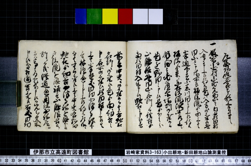
翻刻
【右丁】
乍恐以返答奉願上候御事
一殿山鳥小出村山地元西山之内南新田村
入会事申上候得共是ハ入方ニ御座候野
田山と申場所は桶沢流ゟ南上は
峯通下は小黒川■と申上候得共
板江ゟ来にて山■沢流限此水上に
余程之地広原場所御座候而
是を野田と申候是ゟ下之分
山腰根野田山名所ニ而往古ゟ
両新田村入来申候蛇石と申候者
【左丁】
前方中央ニ御座候而其谷蛇石
名所ニ御座候是ゟ南に細谷之
申名所御座候新田村申上候は
上は峯通丈田切北沢寺弥下
は林際通と申上候得共左様に
而者無御座候上者中召右野田
蛇石ゟ細谷●津寺ねを限下は
戸沢流を銀裾幷山際限右にけ
同断ニ而も澤道通用仕前ね道通
者高は為登不申候而先々ゟ入来
申候処相違無御座候右丈内切
現代語訳
【右丁】
恐れながら返答をもって願い上げ奉る御事
一、殿山(とのやま)について、小出村は山の地元西山の内であると申し上げましたが、これは入り方(境界の内側)にございます。野田山と申す場所は、桶沢の流れより南、上は峯通り、下は小黒川■(判読不能)と申し上げましたが、板江より来る山■沢の流れを限りとし、この水の上流に相当広い原場所(広い平地)がございまして、これを野田と申します。これより下の部分、山の腰根(山裾)の野田山という名所は、往古より両新田村が立ち入って参りました。蛇石と申す者(場所)は、
【左丁】
前方中央にございまして、その谷を蛇石という名所にございます。これより南に細谷という名所がございます。新田村が申し上げましたには、上は峯通り丈・田切・北沢寺弥・下は林際通りと申しましたが、さようではございません。上は中程(中ほど)右の野田、蛇石より細谷・●津寺根を限りとし、下は戸沢の流れを銀裾(山の裾)ならびに山際を限りとし、右(以上)と同じように沢道を通行いたしており、尾根道を通っては登りません。先々(以前)より立ち入って参った通りに相違ございません。右丈(以上の範囲)の内切(境界内)……
英語訳
[Right page]
A Response Humbly Submitted in Reply [to the Previous Petition]
Item: Regarding Tonoyama, although Koide Village has stated that it lies within the western mountain (Nishiyama) of the local mountain territory, this [location] falls within the entry boundary [i.e., inside the disputed zone]. As for the place called Nodayama, [Koide Village] has stated that it extends from the flow of Okesawa to the south, with the ridge road (minetōri) above and the Kogurokawa River below — however, taking the flow of the mountain stream coming from Itae as the boundary, there is a considerably wide open flatland area at the upper reaches of this water, and this is what is called "Noda." The portion below this, at the mountain foothill area known as Nodayama, is a named place where both Shinden villages have had access from ancient times. The place called Jaishi (Serpent Stone) is—
[Left page]
—situated in the center ahead, and that valley constitutes the named place called Jaishi. To the south of this lies a named place called Hosoya. Shinden Village has stated that the upper boundary is the ridge road, Takeda-giri, Kitasawa-tera-ya, and the lower boundary is along the forest edge — however, this is not the case. The upper [boundary] is the mid-range right-hand Noda, extending from Jaishi to Hosoya and ●-dera-ne as the limit, and the lower [boundary] is the flow of Tosawa, with the mountain skirt (ginso) and mountain edge as the limits. In the same manner [as described above], passage is made via the ravine path, and the ridge road is not used for ascending. There is no doubt that [access] has been as it has been from times past. Within the boundaries of the above [described area]...