翻刻
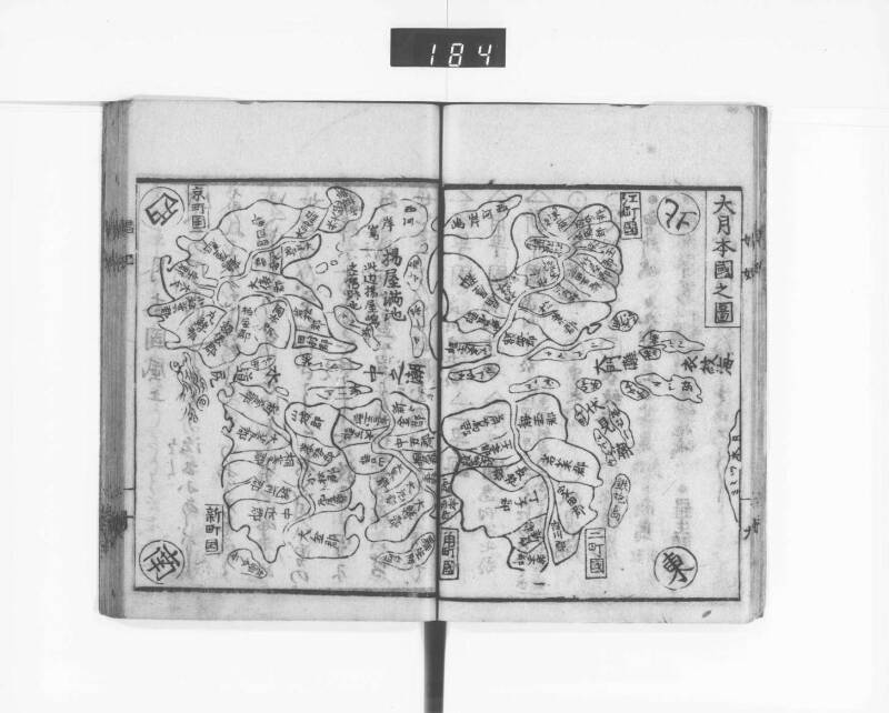
【吉原を国に見立てた図。通りは潮路に、女郎屋等は郡に、江戸町などの町名は島に見立てられている。江町国、二町国、角町国、京町国、新町国の五州については個別の地図もあるので注釈1にまとめてURLを記載した】#1
《題:大月本国之図》
【以下は検索用に主立った文字のみを翻刻する】
衣紋海
大門灘
中之潮
水道尻
鉄炮島
会所シマ【会所島】
商シマ【商島】
茶シマ チヤシマ【茶島】
西河岸島
羅生門島
九郎介シマ【九郎介島、九郎助島】
揚屋満池
此辺揚屋島
之旧跡也
江町国
二町国
角町国
京町国
新町国
東西南北
現代語訳
【吉原を国に見立てた図。通りは潮路に、遊女屋等は郡に、江戸町などの町名は島に見立てられている。江町国、二町国、角町国、京町国、新町国の五州については個別の地図もあるので注釈1にまとめてURLを記載した】
《題:大月本国之図》
【以下は検索用に主立った文字のみを翻刻する】
衣紋海
大門灘
中之潮
水道尻
鉄砲島
会所島
商島
茶島 茶屋島
西河岸島
羅生門島
九郎介島、九郎助島
揚屋満池
このあたり揚屋島の
旧跡なり
江町国
二町国
角町国
京町国
新町国
東西南北
英語訳
[A map depicting Yoshiwara as a country. The streets are represented as tidal channels, the brothels as districts, and town names like Edo-machi as islands. For the five provinces of Edo-machi Country, Ni-chōme Country, Kaku-machi Country, Kyō-machi Country, and Shin-machi Country, individual maps are also available, so URLs are listed in annotation 1]
《Title: Map of Great Getsu-hon Country》
[The following transcribes only the main characters for search purposes]
Emon Sea
Daimon Rapids
Naka-no-shio
Suidō-jiri
Teppō Island
Kaisho Island
Merchant Island
Tea Island Tea House Island
Nishi-gashi Island
Rashōmon Island
Kurōsuke Island, Kurōsuke Island
Agiya-man Pond
Around here are the
historic sites of Agiya Island
Edo-machi Country
Ni-chōme Country
Kaku-machi Country
Kyō-machi Country
Shin-machi Country
East, West, South, North