翻刻
【図題】
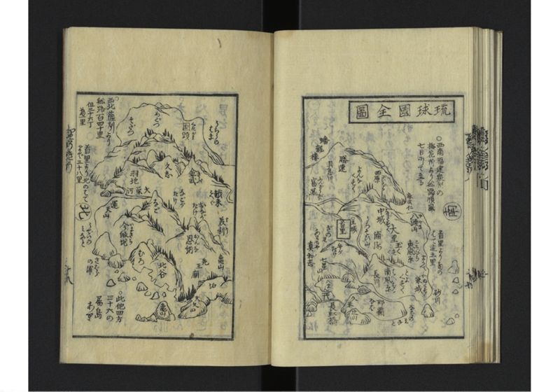
琉球國全圖【横書き】
【右上説明】
〇西南福建泉州
梅花所により舩路順風
七日にして至
【右中説明】
首里より三マミの
はて迠五里
【左上説明】
〇西北薩州より
舩路百四十里
但三十六丁
為一里
【左中説明】
首里より北のはて
まで三十八里
【左下説明】
〇此他四方
三十六の
属島
あり
現代語訳
【図題】
琉球国全図
【右上説明】
○西南は福建泉州
梅花所により船路順風で
七日で到着
【右中説明】
首里より南の果てまで五里
【左上説明】
○西北は薩摩より
船路百四十里
ただし三十六町を
一里とする
【左中説明】
首里より北の果て
まで三十八里
【左下説明】
○この他四方に
三十六の
属島
がある
英語訳
【Map Title】
Complete Map of the Ryukyu Kingdom
【Upper right explanation】
○ To the southwest, Quanzhou in Fujian
With favorable winds from Meihua-sho,
arrival in seven days by ship
【Middle right explanation】
From Shuri to the southern end: five ri
【Upper left explanation】
○ To the northwest, from Satsuma
Ship route: 140 ri
However, 36 chō
equals one ri
【Middle left explanation】
From Shuri to the northern end:
38 ri
【Lower left explanation】
○ In addition to this, in all four directions
there are 36
tributary islands