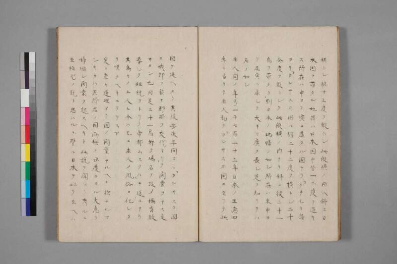
翻刻
【右丁】
横トシ経十三度ヲ縦トシ此縦横ノ内ヘ斜ニ日
本国ヲ帯タル地幡ハ日本国中皆一二度ヲ過キ
ス所在ハ申ヨリ寅ニ扉タル国ナリ「クナシリ島
ヨリ「カンサスカ国ハ緯二十二度ヲ横トシ二十
余度ヲ縦トシテ此縦横ノ内ナリ斜ニ彼二十一
島ヲ帯タリ則日本ノ地幡ノ如シ所在ハ未申ヨ
リ丑寅ニ扉シテ大キニ広ク長シ是ヲ知リテハ
左ノ如シ
赤人国ノ年号一千七百一十三年日本ノ正徳四
年ニ当リテ赤人初テ「カンサスカ国ニ至リテ此
【左丁】
国ヲ従ヘタリ其後安永年間ヨリ「カンサスカ国
ニ城郭ヲ築キ郡県ヲ交代アリテ開業ヲナス事
サカン也因是二十一島都テ嶋名ヲ改メ撫育教
導シテ租税ヲトリテ帝都ムスクハ」ニ送ルナリ
其島々ノ土人モ今ハ已ニ赤人ノ風俗ニ化シタ
リ嘆クヘキニアラスヤ
爰ニ重キ道理アリ国ノ開業ナルヘキ欤ナルマ
シキカハ其所在ノ国両極ノ出度ニヨル大意ヲ
𱞷【諦?】悟シ開業ヲ起スヘキト此説ヲ聞ヨリ考ルニ
至極尤ノ説ト思ハルヽ譬ハ日本ヲ以テ云ヘハ
現代語訳
【右丁】
〔緯度八度を〕横とし、経度十三度を縦として、この縦横の範囲の中に斜めに日本国を帯のように貫く地の幅は、日本国中いずれも一、二度を超えず、その所在は申(南南西)より寅(北北東)の方向に扇を広げた国である。「クナシリ(国後)」島より「カンサスカ(カムチャッカ)」国にかけては、緯度二十二度を横とし、二十余度を縦として、この縦横の範囲の中に斜めに彼の二十一島が帯のように連なっており、すなわち日本の地の幅と同様である。その所在は未申(南南西)より丑寅(北北東)に向けて扇を広げており、大きく広く長い。これを知った上での次第は以下の通りである。
赤人国(ロシア)の年号一千七百十三年、日本の正徳四年にあたり、赤人(ロシア人)が初めて「カンサスカ(カムチャッカ)」国に至って、この
【左丁】
国を従わせた。その後、安永年間よりカムチャッカ国に城郭を築き、郡県を交代させながら開拓事業を盛んに行うようになった。これにより二十一島すべての島名を改め、島民を撫育・教導して租税を取り立て、帝都「ムスクハ(モスクワ)」へ送っているのである。その島々の土人(先住民)も今やすでに赤人の風俗に同化してしまっている。嘆かわしいことではないか。
ここに重要な道理がある。ある国が開拓事業を行うべきか否かは、その所在の国の両極(南北)の出度(緯度)によるものであり、その大意をよく悟った上で開業を起こすべきである、とのこの説を聞いてから考えるに、至極もっともな説と思われる。たとえば日本をもって言えば、
英語訳
**[Right folio]**
Taking [the eight degrees of latitude] as the horizontal measure and the thirteen degrees of longitude as the vertical measure, the breadth of land that Japan occupies diagonally within this vertical-horizontal framework nowhere exceeds one or two degrees across the entire country; Japan is a country whose territory extends diagonally from the direction of *Saru* (south-southwest) to *Tora* (north-northeast). From Kunashiri Island to the land of Kamchatka, taking twenty-two degrees of latitude as the horizontal and over twenty degrees as the vertical, within this framework the twenty-one islands extend diagonally in a band — just like the breadth of Japan's territory. Their location fans out from *Hitsuji-Saru* (south-southwest) toward *Ushi-Tora* (north-northeast), extending broadly, widely, and at great length. Knowing all this, the following should be understood.
In the year 1713 by the reckoning of the country of the Redmen (Russia) — corresponding to the fourth year of Shōtoku in Japan — the Redmen reached the land of Kamchatka for the first time and brought this
**[Left folio]**
country under their dominion. Thereafter, from around the Anei era (1772–1781), they built fortifications in Kamchatka, rotated administrative officials throughout its districts, and engaged vigorously in the work of colonial development. As a result, they renamed all twenty-one islands, collected taxes from the indigenous inhabitants while educating and civilizing them, and sent the revenues to the imperial capital "Musukuha" (Moscow). The native peoples of those islands have already been assimilated into the customs of the Redmen. Is this not cause for lamentation?
Here lies a matter of great importance. Whether a country should undertake colonial development depends on the latitudes (the degrees of the two poles) of the country in question, and one should thoroughly comprehend the general principles before embarking on such development — so runs this argument. Having heard this view, upon reflection, it seems an exceedingly reasonable one. To speak by way of Japan as an example...