翻刻
【右丁】
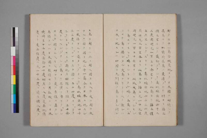
都テ二十一島皆蝦夷地ニテ日本国ニ相続シテ
属島ナリ松前所在島ノ東浦「ノツケ村ヨり海上
僅三里ニシテ最初「クナシリ」島北極出地四十二
三度周廻凡一百五十余里ナリ此島ヨリ海上僅
五六里ニシテ「ストロウ島北極出地四十三四度
周廻凡三百里余ナリ此島ヨリ海上凡一十九里
周廻凡一百五十余里ナリ此外大島ニハ「シモシ
リ島ホコモシリ」嶋ヲンネコタン」嶋ノ三島ハ「ヱ
トロウ島ニ勝レタル大島ナリトイヘリ然レハ
日本ニ比スレハ四国ト九州程ノ島々多シ何レ
【左丁】
モ島ト聞ケハ小ニ聞ヘ国ト云ヘハ大ニ聞ユ大
ナルニ因テ国ト也二十一島合テ日本ニ比スレ
ハ数倍ナルニ過タリ「クナシリ」島北極出地四十
二三度ナリ「カンサスカ国ハ五十四度ナリ「クナ
シリ」ト「カンサスカ」南北ト相距ルヿ経リ二十余
度ナルヘシ「クナシリ」島ヨり丑寅ニ当リテ「カン
サスカ」国ナルヘキ也坤ヨリ艮ノ方位ニ扉タル
島続ナレハ日本国ニ数倍セリ其証拠ニハ日本
長崎三十二度南部四十度相差ヒ八度是南北緯
度ナリ東西経度ハ凡一十三度ニ過ス緯八度ヲ
現代語訳
【右丁】
合わせて二十一島、いずれも蝦夷地であり、日本国に連なる属島である。松前所在の島の東浦「ノツケ村」より海上わずか三里にして、まず最初に「クナシリ(国後)」島があり、北極出地(北緯)四十二、三度、周囲およそ百五十余里である。この島よりさらに海上わずか五、六里にして「エトロウ(択捉)」島があり、北極出地四十三、四度、周囲およそ三百里余りである。この島よりさらに海上およそ十九里にして〔ある島があり〕、周囲およそ百五十余里である。この他、大きな島としては「シモシリ(新知)」島・「ホコモシリ(幌筵)」島・「ヲンネコタン(温禰古丹)」島の三島は、「エトロウ(択捉)」島に勝るとも劣らぬ大きな島であるといわれる。されば日本に比すれば四国や九州ほどの島々が多くある。いずれも
【左丁】
「島」と聞けば小さく聞こえ、「国」といえば大きく聞こえる。大きいがゆえに「国」ともいう。二十一島を合わせて日本と比較すれば、数倍にも及ぶほどである。「クナシリ(国後)」島の北極出地(北緯)は四十二、三度である。「カンサスカ(カムチャッカ)」国は五十四度である。「クナシリ」と「カンサスカ」が南北に隔たること、経(緯度差)にして二十余度あるはずである。「クナシリ」島より丑寅(北北東)の方角に当たって「カンサスカ」国があるはずである。坤(南西)より艮(北東)の方位に扇を広げるように島が続くため、日本国の数倍に及ぶのである。その証拠には、日本の長崎が三十二度、南部(陸奥南部・盛岡あたり)が四十度と、その差は八度、これが南北の緯度差である。東西の経度差はおよそ十三度に過ぎない。緯度八度を〔基準として……〕
英語訳
**[Right folio]**
In total, there are twenty-one islands, all of which are Ezo territory (蝦夷地) and dependent islands forming a continuous chain belonging to Japan. From "Notsuke Village" on the eastern shore of the island where Matsumae is located, at a mere three *ri* across the sea, lies the first island: "Kunashiri" (Kunashir), at a northern latitude of approximately 42–43 degrees, with a circumference of roughly 150-odd *ri*. From this island, only five or six *ri* across the sea, lies "Etorou" (Iturup) Island, at a northern latitude of approximately 43–44 degrees, with a circumference of roughly 300-odd *ri*. From this island, approximately nineteen *ri* across the sea, lies [another island] with a circumference of approximately 150-odd *ri*. Among the other large islands, "Shimoshiri" (Simushir), "Hokomoshiri" (Paramushir), and "Onnekōtan" (Onekotan) — these three islands are said to surpass even "Etorou" in size. When compared to Japan, there are many islands as large as Shikoku or Kyushu.
**[Left folio]**
When called "islands," they sound small; when called "countries," they sound large. Because they are so large, they may also be called "countries." The twenty-one islands combined are several times the size of Japan. The northern latitude of Kunashiri Island is 42–43 degrees. The land of "Kansasuka" (Kamchatka) lies at 54 degrees. The north-south separation between Kunashiri and Kamchatka amounts to over twenty degrees of latitude. Kamchatka should lie in the direction of *Ushi-Tora* (north-northeast) from Kunashiri Island. Since the chain of islands fans out from the southwest (*Kun*, 坤) to the northeast (*Gen*, 艮), it surpasses Japan several times over in extent. As evidence: in Japan, Nagasaki lies at 32 degrees and Nanbu (the southern part of Mutsu Province) at 40 degrees — a difference of eight degrees — this being the north-south latitudinal span. The east-west longitudinal span is only approximately 13 degrees. Taking the eight degrees of latitude as [a reference...]