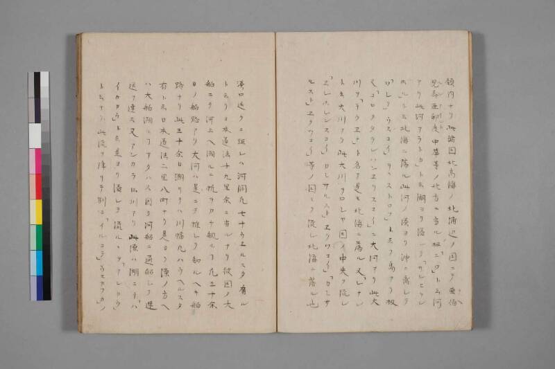
翻刻
【右丁】
領内ナリ此諸国北髙海ノ北浦辺ノ国ニテ亜伯(アヘ)
児斉亜(ルシア)印度(インド)中華等ノ北方ニ当ル扨「ニワ」ト云河
アリ此河アラトカ」ト云湖ヨリ溢レテ「サンヒケン
ホル」ト云北浦ニ落ル此河ノ湊ヨリ沖ニ離レテ
「ワシリ」ウスコイ」ヲヽストロフ」ト云フ島アリ扨
又「コロクタランハンヱリスコイ」ニ大河アリ此大
川ヲ「テウヱナ」ト名テ是モ北海ニ落ル又「レナン
ト云大川アリ此大川ヲロシヤ国ノ中央ヲ流レ
「ヱレホレンスコイ」カシサルスト」ヱクツコイ」「カレサ
ルスト」ヱクツコイ」等ノ国々ヲ流レ北海ニ落ル也
【左丁】
湊口近クニ距レハ河潤凡七十ウヱルスタ有ル
ト云リ日本道法十九里余ニ当ルナリ彼国ノ大
舶ニテ河上ヘ遡ルニ帆ヲカケ䑺ルヿ凡三十余
日ノ舶路アリ大河ハ是ニテ推シテ知ルヘキ舶
路ナリ此三十余日遡リテハ川幅凡八ウヘルスタ
有ト云日本道法二里八町ナリ是ヨリ源ノ方ヘ
ハ大舶遡ルヿアタハス因テ河船ニ通船シテ運
送ヲ達ス又アンカラト云川アリ此源ハ湖ニテ「ハ
イカカウ」ト云是ヨリ溢レテ流ルヽヲ「アンカウ」
ト云ナリ此流ヲ降リテ別ニ「イルコテ」ウセカフカ」ノ
現代語訳
【右丁】
(前頁より続き)領内である。これらの諸国は北高海(北極海)の北の沿岸に位置する国々であり、亜伯児斉亜(アベルシア=ペルシア)・印度(インド)・中華(中国)等の北方にあたる。さて、「ニワ(ネヴァ川)」という河がある。この河は「アラトカ(ラドガ)」という湖から溢れ出て、「サンヒケンホル(フィンランド湾)」という北の浦(湾)に注ぎ込む。この河の河口から沖に離れたところに「ワシリウスコイ・ヲヽストロフ(ヴァシリエフスキー島)」という島がある。さて、また「コロクタランハンヱリスコイ(?)」に大河がある。この大河を「テウヱナ(ドヴィナ川)」と名付け、これもまた北海(北極海)に注ぎ込む。また「レナン(レナ川)」という大河がある。この大河はロシア国の中央を流れ、「ヱレホレンスコイ(?)」「カシサルスト・ヱクツコイ(?)」「カレサルスト・ヱクツコイ(?)」等の国々を流れて北海(北極海)に注ぎ込む。
【左丁】
河口付近の幅は凡そ七十ウヱルスタ(ヴェルスタ)あると言われている。日本の道法に換算すると十九里余りにあたる。かの国(ロシア)の大きな船で川を遡るのに帆をかけて漕ぐこと、凡そ三十余日の船旅がある。大河というものはこれをもって推して知るべき船路である。この三十余日遡ったところでは、川幅は凡そ八ウヱルスタあると言う。日本の道法で二里八町にあたる。これより源の方へは大きな船で遡ることができない。そのため川船に乗り換えて通船し、輸送を行う。また「アンカラ(アンガラ川)」という川がある。この源は湖であり、「ハイカカウ(バイカル湖)」という。これより溢れ出て流れるものを「アンカウ(アンガラ)」と言う。この流れを下ると、別に「イルコテ(イルクーツク)」「ウセカフカ(?)」の
英語訳
[Right folio]
(Continued from previous page) ...are within Russian territory. These various countries lie along the northern shores of the Northern High Sea (Arctic Ocean), situated to the north of Persia, India, China, and similar lands. Now, there is a river called "Niwa" (the Neva River). This river overflows from a lake called "Aratoka" (Lake Ladoga) and empties into a northern bay called "Sanhikenhor" (the Gulf of Finland). Offshore from the mouth of this river, there is an island called "Washiriusukoi Oosutorofu" (Vasilyevsky Island). Furthermore, in "Korokutaran Han'erisukoi" (unknown region), there is a great river. This great river is named "Teuena" (the Northern Dvina River), which also flows into the Northern Sea (Arctic Ocean). There is also a great river called "Renan" (the Lena River). This great river flows through the center of Russia, passing through the countries of "Erehorensukoi," "Kashisarusuto Ekutsukoi," "Karesarusuto Ekutsukoi," and others, before emptying into the Northern Sea (Arctic Ocean).
[Left folio]
Near the river's mouth, the width is said to be approximately seventy Vёrsts. In Japanese units of measurement, this corresponds to more than nineteen ri. Traveling upstream on this river by large Russian vessel under sail and oar takes approximately thirty or more days of sailing. The scale of these great rivers can be inferred from this voyage alone. After traveling upstream for these thirty-plus days, the river's width is said to be approximately eight Vёrsts — equivalent to two ri and eight chō in Japanese measurement. Beyond this point, large vessels cannot proceed upstream. Therefore, river boats are used to continue navigation and carry goods. There is also a river called "Ankara" (the Angara River). Its source is a lake called "Haikakau" (Lake Baikal). The river that overflows and flows from this lake is called "Ankau" (Angara). Descending along this flow, one separately reaches "Irukote" (Irkutsk) and "Usekafuka" (?)...