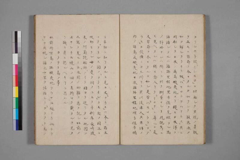
翻刻
【右丁】
カリシカ予彼「イシユヨ」ニ対面シテ其説ノ真疑
ヲ正スニ符節ヲ合セタルカ如クシテ疑惑氷ノ
如ク解シタリケリ扨「ハセロウフハアウス」共ニ
同船シテ日本ノ属島蝦夷地ヨリ段々日本洋ヲ
渉海シタルハ海路里程地里方位ヲ見探ラン為
ノ計略ナレハ所々ニ於テ測量セシヿ風説考ニ
モ見ヘタレハ猶モ念入リテ「イユヲ」ニ尋ルニ是
又符節ヲ合セタルカ如シ是皆「ハセロウラ」ト「ア
ウス」カ俊傑ニヨル所ナリ其以後赤人共東洋ノ
内ノ諸島及蝦夷地日本海路里程地里方位等猶
【左丁】
々委細ニ知リタルト見ユ又「アウス」ハ今ニ存生
ニテ「フランス国ノ「アテリイン」ト云処ノ国王ニ
扶助セラン世ノ変ヲ伺フト云リ予例年長崎渡
来ノ阿蘭陀舶師「ノイテ国ヨリ送リタル地図ノ
正写ヲ見ルニ日本国ノ四海ヲ悉ク記シ松前ノ
ヱサシチト云焼山ノ煙ノ立所マテ載タルヲ見タ
リ誠ニ真ニ恐ルヘキヿト思ハル
カラフト島ノ事
松前所在島ノ西蝦夷地ソウヤ」ト云処アリ此クウ
ヤ」ヲ出帆シ海上十里ヲ渉海シテ「カラフト」島ノ
現代語訳
【右丁】
(前頁より続き)疑わしく思っていたところ、私が彼「イシユヨ(イシヨ)」に対面して、その説の真偽を正すと、符節を合わせたように(ぴったりと符合して)、疑惑は氷のように解けた。
さて、「ハセロウフ(ハセロフ)」と「アウス」は共に同船して、日本の属島・蝦夷地からさらに日本洋(日本近海)を渡海したのは、海路・里程・地里・方位を見探るための計略であったから、各所において測量したことが、風説考(風説書の考察)にも見受けられた。さらに念を入れて「イユヲ(イヨ)」に尋ねると、これもまた符節を合わせたように(話が合った)。これはみな「ハセロウラ(ハセロフ)」と「アウス」の俊傑(優れた才能)によるところである。その後、ロシア人たちは東洋の諸島および蝦夷地・日本の海路・里程・地里・方位等を、ます
【左丁】
ます委細に(詳しく)知るに至ったと見える。また「アウス」は今も存命であって、「フランス国」の「アテリイン(アテネ?)」と言う所の国王に扶助されながら、世の変(時勢の変化)を伺っているとのことである。
私が例年(毎年)長崎に渡来するオランダ船の船師(船長)が「ノイテ国(スウェーデン?)」より送ってきた地図の正写(正確な写し)を見るに、日本国の四海(四方の海)をことごとく記し、松前の「ヱサシ(江差)」という焼山(火山)の煙の立ちのぼる所まで載せてあるのを見た。まことに真に恐るべきことと思われる。
カラフト島のこと
松前所在の島の西・蝦夷地の「ソウヤ(宗谷)」という処がある。この「ソウヤ」を出帆し、海上十里を渡海して「カラフト」島の
(次頁へ続く)
英語訳
[Right folio]
(Continued from previous page) —and being deeply suspicious, I met face-to-face with "Ishiyo" (Ishio) to verify the truth or falsehood of his account, whereupon the pieces fit together like a tally-stick matched to its counterpart, and my doubts dissolved like ice.
Now, "Khaselov" (Khaseróf) and "Ausu" had sailed together aboard the same vessel from the Japanese dependency of Ezo (Hokkaido), and had subsequently crossed the Japanese seas (the waters surrounding Japan) — this was a stratagem devised to survey and reconnoiter the sea routes, distances, geographical measures, and bearings. That they had conducted surveys at various places along the way is also evident from examinations of the "fūsetsu-kō" (reviews of intelligence reports on foreign affairs). When I inquired further of "Iyo" with even greater care, the account again matched perfectly, like a tally-stick. All of this is owing to the exceptional talent and brilliance of "Khaseróf" and "Ausu." After that, it appears that the Russians came to know the various islands of the East and the lands of Ezo, along with Japan's sea routes, distances, geographic positions, and bearings, in ever-
[Left folio]
—greater and more precise detail. Furthermore, it is said that "Ausu" is still alive today, being supported by the king of a place called "Ateriin" (Athens?) in "France" (or a French-affiliated territory), and is waiting and watching for a change in the tide of world affairs.
When I examined the accurate copy of a map sent from "Noite-koku" (Sweden?) by the Dutch ship's captain who makes his annual voyage to Nagasaki, I found that it recorded all four seas surrounding Japan in their entirety, even marking the location of the rising smoke of the volcanic mountain at "Esashi" in Matsumae (Hokkaido). I could not but think this a truly fearsome matter.
On the Island of Karafuto (Sakhalin)
To the west of the islands in the vicinity of Matsumae, in the Ezo lands, there is a place called "Sōya" (Cape Soya). Departing from this "Sōya" by ship, one crosses ten ri (approximately 40 km) of open sea to reach the island of "Karafuto" (Sakhalin)—
(Continued on next page)