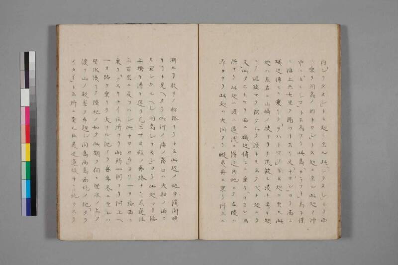
翻刻
【右丁】
内「シラタヌシ」ト云処ニ至ル此「シラヌシ」ヨリ西
ニ乗リ同島ノ内ナヨシ」ト云処ニ至ル此処ノ沖
中ニ海上六七里ヲ隔ツト云リ又「ナヨシ」ヨリ西ニ
磯辺伝ヒニ乗リテ「ヲハトマリ」ト云処ニ至ル此
処ハ左右ニ山崎ノ峡アリテ風波モ凌キ易キ処
ニテ涯端マテ深クシテ湊トモ云フベキ処ニテ
又此ヲホトマリ西ニ磯辺伝ヒニ乗リ「ナヨロト云
所アリ此処ハ涯ハ遠浅ニ浜辺沙地ニテ丘陵ハ
平カナリ此処ハ大河アリ蝦夷舟ニ乗リ河上ニ
【左丁】
遡ルヿ数日ノ船路ナリト云此返ノ地中渓間曠
キヿト見ヘタリ此河ノ海ノ落口ハ大船ノ泊ニ
モ宜シカルヘシ同島シラスン」ヨリ此処マテ海
上掻キ漕キ送リ凡二十日程ノ舟路ナリ其道法
三百里ニ及フハシ此ナヨロウ」ヨリ一日路西ニ
乗リ「クスリナイト云所アリ此所一河アリ河上ヘ
一日路ヲ乗リテ大ナル池アリ毎年冬ニ至レハ
堅氷張リテ陸地ノ如ク此期ヲ伺ヒ堅氷ノ上ヲ
渡リ山ノ数峯ヲ歩越シ同島西島西北ノ地「タラ
イカイ」ト云所ニ至ルト云是近道故ナリ北クスリ
現代語訳
【右丁】
(前頁より続き)その内「シラヌシ」と言う処に至る。この「シラヌシ」より西に乗り(進み)、同島の内「ナヨシ」と言う処に至る。この処の沖中に海上六・七里を隔てるとのことである。また「ナヨシ」より西に磯辺伝いに乗りて「ヲホトマリ(大泊)」と言う処に至る。この処は左右に山崎の峡(山の岬が形成する海峡)があり、風波も凌ぎやすい処であって、岸端まで深くして湊(港)とも言うべき処である。またこの「ヲホトマリ」より西に磯辺伝いに乗り、「ナヨロ」という所がある。この処は岸は遠浅にして浜辺は砂地で、丘陵は平らかである。この処には大きな川があり、蝦夷の舟に乗り川上に
【左丁】
遡ること数日の船路なりとのことである。この辺りの地の中(内陸)は渓間(谷間)が広々としているように見える。この川の海への落口(河口)は大きな船の泊まりにも宜しいであろう。同島の「シラヌシ」よりこの処まで、海上を漕ぎ送り(舟を漕いで進み)、およそ二十日程の舟路である。その道法(距離)は三百里に及ぶであろう。この「ナヨロ」より一日路(一日の行程)西に乗り、「クスリナイ」と言う所がある。この所に一つの川があり、川上へ一日路を乗りて大きな池がある。毎年冬に至れば堅氷(厚い氷)が張って陸地のごとくなり、この時期を伺い、堅氷の上を渡り、山の数峯を歩き越し、同島西・西北の地「タライカイ」と言う所に至るとのことである。これは近道であるためである。北「クスリ
(次頁へ続く)
英語訳
[Right folio]
(Continued from previous page) —reaching a place within it called "Shiranushi." From this "Shiranushi," one proceeds westward to a place called "Nayoshi" on the same island. It is said that in the offing at this location, there is a distance of six or seven ri across open sea. Continuing westward from "Nayoshi" along the coastline, one arrives at a place called "Wohotomari" (Ōtomari / Korsakov). At this location, there are narrow inlets formed by mountain promontories to the left and right, making it a place where wind and waves are easy to weather; the water is deep right up to the shore's edge, and it is a place that could rightly be called a harbor. Continuing further west from this "Ōtomari" along the coastline, there is a place called "Nayoro." This place has a shallow coastal shelf, with sandy beaches and gently rolling, flat hillocks. Here there is a large river, and it is said that one may travel upstream by Ezo-style boat
[Left folio]
for several days' journey by water. The interior of the land in this vicinity appears to consist of broad, open valley terrain. The mouth of this river where it meets the sea would likely be suitable as an anchorage for large ships. From "Shiranushi" on the same island to this place, paddling and rowing along the coast, is approximately a twenty-day journey by boat. The distance is said to amount to some three hundred ri (approximately 1,200 km). Proceeding one day's journey westward from this "Nayoro," there is a place called "Kusuri-nai." At this location there is a single river, and traveling one day's journey upstream, there is a large lake. Every year when winter arrives, thick ice forms over it, rendering it like solid land; taking advantage of this season, one crosses over the solid ice, traverses several mountain peaks on foot, and arrives at a place called "Taraikhai" in the western and northwestern part of the same island. This is because it serves as a shortcut. North "Kusuri—
(Continued on next page)