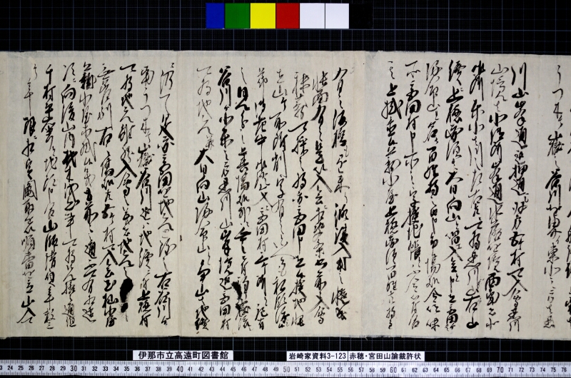
翻刻
うつ木ヶ嶽之谷川を界イ東北之方者黒
川山峯通迄押通し双方五ヶ村可入会黒川
山境者北御所峯通水落を境西南者北
御所東北者川之左右共二可為黒川山右山
續ニ上穂赤須者大日向山と唱ェ入会と申立宮田ゟは
帰命山と名ヶ百姓持之由申争場処令吟味
所宮田村申所之字検地帳と不令符合
其上掛置候薪小屋上穂赤須百姓共持主
有之仮橋も懸来り修復入用之慥成
帳面有之是以入会ニ相決条書前ニ入会
秣薪可採之将亦宮田申立候検地帳
は山ヶ所附削字有之といへとも私領渡し候
節御老中御證文ニ宮田村三ヶ所と記有
之見分之上其場処外に無之ニ付駒ケ嶽流ㇾ
谷川ゟ北東之方黒川山峯境迄宮田村
可為地元幷大日向山帰命山と争山者地續
ニ仍て是亦宮田を地元と致し右谷川ゟ
南うつ木ヶ嶽谷川迄ㇵ地續ニ付上穂村
可為地元雖然入会之義者地元之□□
無差別右之場処共五ヶ村可入会尤杣小屋
薪小屋等掛候義者前々之通不可有相違
次ニ向後山内材木伐出事可為先格之通但
千村平右衛門と地頭申合山師請負年数三
ケ年限ニ相定鬮取を以順番を立山入可
現代語訳
うつ木ヶ岳の谷川を境界とし、東北の方は黒川山の峰通りまで押し通し、双方五ヶ村が入会できるものとする。黒川山の境界は、北御所峰通りの水落を境とし、西南は北御所、東北は川の左右共に黒川山とするべきである。右の山に続いて上穂赤須は大日向山と唱え入会と申し立て、宮田からは帰命山と名付け百姓持ちであると申し、争いの場所について吟味を命じた。
ところが宮田村が申し立てる字検地帳と符合しない。その上、掛け置いてある薪小屋は上穂赤須の百姓共が持ち主であり、仮橋も掛けて来て修復費用の確かな帳面がある。これを以って入会に相決まり、条書きの前に入会して秣薪を採ることができる。
また宮田が申し立てる検地帳には山ヶ所の付け削りの字があるといえども、私領を渡した際の御老中の御証文に宮田村三ヶ所と記載があり、見分の上その場所の他にはない。よって駒ヶ岳から流れる谷川より北東の方、黒川山峰境まで宮田村を地元とするべきである。
並びに大日向山・帰命山という争いの山は地続きであるため、これもまた宮田を地元とし、右の谷川より南のうつ木ヶ岳谷川までは地続きのため上穂村を地元とするべきである。
しかしながら入会の義については地元の〔判読不明〕に差別なく、右の場所共に五ヶ村が入会できるものとする。もっとも杣小屋・薪小屋等を掛ける義は前々の通り相違があってはならない。
次に今後山内の材木伐出のことは先格の通りとするべきである。ただし千村平右衛門と地頭が申し合わせ、山師請負の年数を三ヶ年限りと相定め、くじ取りを以って順番を立て山入りができる。
英語訳
Using Utsuki-ga-take Valley River as the boundary, the northeastern area shall extend through to the Kurokawa Mountain ridge, and both sides' five villages may have joint access rights (iriai). The boundary of Kurokawa Mountain shall be the water drop point along the Kitago-sho ridge as the border, with the southwest being Kitago-sho and the northeast being designated as Kurokawa Mountain on both the left and right sides of the river.
Continuing to the right mountain, Kaho-Akasu claims it as Dainichi-muko Mountain with joint access rights, while Miyata calls it Kimyo Mountain, claiming it belongs to the farmers. An investigation was ordered regarding this disputed location.
However, this does not correspond with the land survey register (kenchi-cho) that Miyata Village claims. Moreover, the firewood huts placed there belong to the farmers of Kaho-Akasu, and they have also built temporary bridges with reliable account books for repair expenses. Based on this, joint access rights were decided, allowing the harvesting of grass and firewood before the written conditions.
Furthermore, while the land survey register that Miyata claims has attached deletion marks for mountain locations, the certificate from the Senior Councilors when the private domain was transferred records "three locations in Miyata Village," and upon inspection, there are no other such places. Therefore, from the valley river flowing from Koma-ga-take northeastward to the Kurokawa Mountain ridge boundary, Miyata Village shall be designated as the local authority.
Additionally, since the disputed mountains called Dainichi-muko Mountain and Kimyo Mountain are geographically continuous, Miyata shall also be designated as the local authority for these. From the aforementioned valley river south to Utsuki-ga-take Valley River, being geographically continuous, Kaho Village shall be designated as the local authority.
However, regarding joint access rights, without discrimination against the local [illegible text], all five villages may have joint access to these locations. Particularly, the matter of placing logging huts and firewood huts shall remain as before without any changes.
Next, future timber cutting in the mountain areas shall follow previous precedents. However, Chison Heiemon and the territorial lord shall agree that the mountain contractor's term shall be limited to three years, with mountain access determined by establishing a rotation system through drawing lots.